iFlightPlanner Releases v2.2 | Aero-News Network
Aero-News Network
RSS icon RSS feed
podcast icon MP3 podcast
Subscribe Aero-News e-mail Newsletter Subscribe

Airborne Unlimited -- Most Recent Daily Episodes

Episode Date

Airborne-Monday

Airborne-Tuesday

Airborne-Wednesday Airborne-Thursday

Airborne-Friday

Airborne On YouTube

Airborne-Unlimited-05.19.25

Airborne-NextGen-05.20.25

AirborneUnlimited-05.21.25

Airborne-AffordableFlyers-05.22.25

AirborneUnlimited-05.23.25

Mon, Jul 28, 2014

iFlightPlanner Releases v2.2

New Features Include Georeferenced Diagrams And Procedures

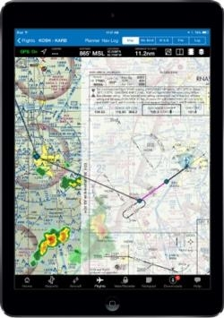
iFlightPlanner has released v2.2 for iPad, the third major update this year to iFlightPlanner for the device presented by Sennheiser.  In addition to numerous performance and usability enhancements, v2.2 now offers the comprehensive set of high-resolution, georeferenced FAA airport diagrams and instrument approach procedures.

The new georeferenced airport diagrams and instrument approach procedures are accessible throughout iFlightPlanner for iPad, including its split-screen view, and can be easily placed over iFlightPlanner’s seamless VFR and IFR charts with a single tap.  Pilots can then use the intuitive mini-menu to quickly search for and switch between other diagrams or approach procedures and adjust the transparency of each.

“We developed our own, proprietary georeferencing process so that when viewed as standalone documents, iFlightPlanner could provide the georeferenced airport diagrams and approach procedures in their original PDF format,” said John Burnside, iFlightPlanner’s Co-Founder & Director of Technology.  “Doing this fully-leverages the pinch and zoom capabilities of the iPad and provides crystal clear readability at any zoom level.”

iFlightPlanner also enhanced its implementation of the Baron Weather API as part of this release, offering pilots the ability to adjust the transparency of RADAR and satellite imagery displayed over its charts and maps.

The new graphical weather functionality is available to all iFlightPlanner Free and Premium members.  Georeferenced airport diagrams and approach procedures are available to iFlightPlanner Premium Plus members, a new membership level introduced to give pilots flying with iFlightPlanner for iPad greater functionality.

(Image provided by iFlightPlanner)

FMI: www.iFlightPlanner.com/Features

Advertisement

More News

Oshkosh Memories: An Aero-News Stringer Perspective

From 2021: The Inside Skinny On What Being An ANN Oshkosh Stringer Is All About By ANN Senior Stringer Extraordinare, Gene Yarbrough The annual gathering at Oshkosh is a right of p>[...]

NTSB Prelim: Piper PA32RT

Video Showed That During The Takeoff, The Nose Baggage Door Was Open On May 10, 2025, about 0935 eastern daylight time, a Piper PA-32RT-300, N30689, was destroyed when it was invol>[...]

ANN FAQ: Follow Us On Instagram!

Get The Latest in Aviation News NOW on Instagram Are you on Instagram yet? It's been around for a few years, quietly picking up traction mostly thanks to everybody's new obsession >[...]

Aero-News: Quote of the Day (05.28.25)

"I think what is key, we have offered a bonus to air traffic controllers who are eligible to retire. We are going to pay them a 20% bonus on their salary to stay longer. Don't reti>[...]

ANN's Daily Aero-Term (05.28.25): Pilot Briefing

Aero Linx: Pilot Briefing The gathering, translation, interpretation, and summarization of weather and aeronautical information into a form usable by the pilot or flight supervisor>[...]

blog comments powered by Disqus


Advertisement

Advertisement

Podcasts

Advertisement

© 2007 - 2025 Web Development & Design by Pauli Systems, LC