iFlightPlanner Releases v2.2 | Aero-News Network
Aero-News Network
RSS icon RSS feed
podcast icon MP3 podcast
Subscribe Aero-News e-mail Newsletter Subscribe

Airborne Unlimited -- Most Recent Daily Episodes

Episode Date

Airborne-Monday

Airborne-Tuesday

Airborne-Wednesday Airborne-Thursday

Airborne-Friday

Airborne On YouTube

Airborne-Unlimited-05.19.25

Airborne-NextGen-05.20.25

AirborneUnlimited-05.21.25

Airborne-AffordableFlyers-05.22.25

AirborneUnlimited-05.23.25

Mon, Jul 28, 2014

iFlightPlanner Releases v2.2

New Features Include Georeferenced Diagrams And Procedures

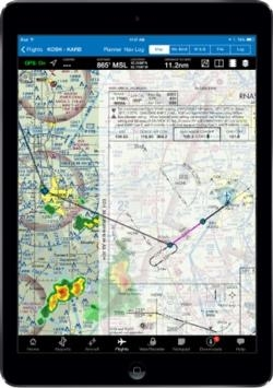
iFlightPlanner has released v2.2 for iPad, the third major update this year to iFlightPlanner for the device presented by Sennheiser.  In addition to numerous performance and usability enhancements, v2.2 now offers the comprehensive set of high-resolution, georeferenced FAA airport diagrams and instrument approach procedures.

The new georeferenced airport diagrams and instrument approach procedures are accessible throughout iFlightPlanner for iPad, including its split-screen view, and can be easily placed over iFlightPlanner’s seamless VFR and IFR charts with a single tap.  Pilots can then use the intuitive mini-menu to quickly search for and switch between other diagrams or approach procedures and adjust the transparency of each.

“We developed our own, proprietary georeferencing process so that when viewed as standalone documents, iFlightPlanner could provide the georeferenced airport diagrams and approach procedures in their original PDF format,” said John Burnside, iFlightPlanner’s Co-Founder & Director of Technology.  “Doing this fully-leverages the pinch and zoom capabilities of the iPad and provides crystal clear readability at any zoom level.”

iFlightPlanner also enhanced its implementation of the Baron Weather API as part of this release, offering pilots the ability to adjust the transparency of RADAR and satellite imagery displayed over its charts and maps.

The new graphical weather functionality is available to all iFlightPlanner Free and Premium members.  Georeferenced airport diagrams and approach procedures are available to iFlightPlanner Premium Plus members, a new membership level introduced to give pilots flying with iFlightPlanner for iPad greater functionality.

(Image provided by iFlightPlanner)

FMI: www.iFlightPlanner.com/Features

Advertisement

More News

NTSB Prelim: Lee Aviation LLC JA30 SuperStol

A Puff Of Smoke Came Out From The Top Of The Engine Cowling Followed By A Total Loss Of Engine Power On May 9, 2025, about 1020 mountain daylight time, an experimental amateur-buil>[...]

Classic Aero-TV: Curtiss Jenny Build Wows AirVenture Crowds

From 2022 (YouTube Edition): Jenny, I’ve Got Your Number... Among the magnificent antique aircraft on display at EAA’s AirVenture 2022 was a 1918 Curtiss Jenny painstak>[...]

ANN's Daily Aero-Term (05.30.25): Very High Frequency (VHF)

Very High Frequency (VHF) The frequency band between 30 and 300 MHz. Portions of this band, 108 to 118 MHz, are used for certain NAVAIDs; 118 to 136 MHz are used for civil air/grou>[...]

Aero-News: Quote of the Day (05.30.25)

“From approximately November 2021 through January 2022, Britton-Harr, acting on behalf of AeroVanti, entered into lease-purchase agreements for five Piaggio-manufactured airc>[...]

ANN's Daily Aero-Term (05.31.25): Microburst

Microburst A small downburst with outbursts of damaging winds extending 2.5 miles or less. In spite of its small horizontal scale, an intense microburst could induce wind speeds as>[...]

blog comments powered by Disqus


Advertisement

Advertisement

Podcasts

Advertisement

© 2007 - 2025 Web Development & Design by Pauli Systems, LC