Fri, Feb 06, 2015
Includes Graphical Weather Data, Route Planning Tools
Jeppesen, has introduced a new version of its popular flight information solution for private pilots who fly under visual flight rules – Mobile FliteDeck VFR. The new 2.0 version of the iPad-based Mobile FliteDeck VFR solution builds on its ability to simplify complex procedures and present critical flight information and real-time data that is uniquely displayed per the preference of the pilot.
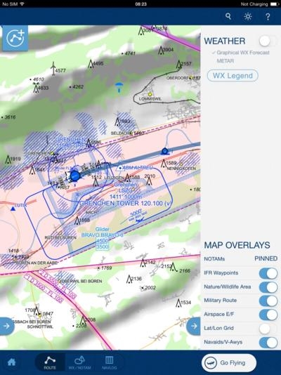
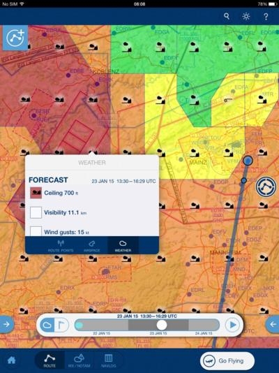
Mobile FliteDeck VFR now provides pilots with essential data-driven weather forecasts that can seamlessly integrate with other information on screen. In planning and in-flight modes, graphic color-coded weather data is presented as a layered overlay option, to improve awareness and related decision making processes. As with other Mobile FliteDeck VFR capabilities, weather forecast overlay data can be viewed in greater detail using pinch and zoom navigation functionality that is automatically rendered on the chart, per pilot need.
“Our latest version of Mobile FliteDeck VFR continues our efforts to provide private pilots with a focused software solution that reduces workload and enhances decision making,” said Tim Huegel, director, Jeppesen Aviation Portfolio Management. “We designed our new graphical weather data overlay feature from scratch. It is an example of how we continually strive to provide an innovative user experience by gaining a deep understanding of the needs of pilots through ongoing interaction and study of actual workflow processes.”
A new “Weather Controller” slider bar feature combines multiple weather data points within a single on-screen display control. It includes the ability to toggle between color-coded forecast data, multiple wind speed information by elevation and other weather phenomena in an easy to use interface. The Weather Controller bar can be manipulated with the slide of a finger, or used in a video play mode to view data sequentially. When using manual pinch and zoom weather data overlay functionality on the navigation chart, additional symbols become visible while zoomed in on color-coded weather data, to provide further detail and clarity. Overall, the colors used for overlays allows for quick pilot comprehension of weather condition severity, including adverse conditions.
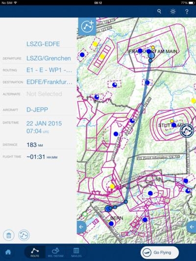
In addition to new weather data features, the new Mobile FliteDeck VFR version also introduces bearing and distance indications for all waypoints and airports on the map in “live” mode. In Europe, pilots will enjoy added IFR waypoints and improved waypoint search capabilities. U.S. pilots will notice improved temporary flight restriction (TFR) data display, featuring airspace labels, vertical limits and effective times. A refined NavLog feature will now also automatically ingest winds aloft into calculations and display, while numerous other software and operating system improvements will improve the user experience for VFR pilots.
(Screenshots provided by Jeppesen)
More News
Omnidirectional Approach Lighting System ODALS consists of seven omnidirectional flashing lights located in the approach area of a nonprecision runway. Five lights are located on t>[...]
"Polaris Dawn, the first of the program’s three human spaceflight missions, is targeted to launch to orbit no earlier than summer 2024. During the five-day mission, the crew >[...]
Also: 1800th E-Jet, Uncle Sam Sues For Landing Gear, Embraer Ag Plane, Textron Parts A friend of the family reported that Lt. Col. (Ret.) Richard Glenn Rutan flew west on Friday, M>[...]
Also: Virgin Galactic, B-29 Doc to Allentown, Erickson Fire-Fighters Bought, FAA Reauthorization After dealing with a big letdown after the unexpected decision by Skyreach to disco>[...]
“Our aircrews are trained and capable of rapidly shifting from operational missions to humanitarian roles. We planned to demonstrate how we, and our BORSTAR partners, respond>[...]
 ANN's Daily Aero-Term (05.05.24): Omnidirectional Approach Lighting System

