Ikhana Flies Vital Mission For Second Year
A remotely piloted aircraft carrying a NASA sensor flew over
much of California last week, gathering information that will be
used to help fight more than 300 wildfires burning within the
state. Additional flights are planned for this week as well,
as large areas of the Golden State continue to burn.
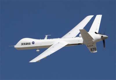
The flights by NASA's unmanned Ikhana aircraft are using a
sophisticated Autonomous Modular Scanner developed at NASA's Ames
Research Center at Moffett Field, CA. The flights are originating
from NASA's Dryden Flight Research Center at Edwards Air Force
Base, CA. Ikhana's onboard sensor can detect temperature
differences from less than one-half degree to approximately 1,000
degrees Fahrenheit. The scanner operates like a digital camera with
specialized filters to detect light energy at visible, infrared and
thermal wavelengths.
NASA and the US Department of Agriculture's Forest Service have
partnered to obtain imagery of the wildfires in response to
requests from the California Department of Forestry and Fire
Protection, the California Governor's Office of Emergency Services
and the National Interagency Fire Center.
"NASA's emergency imaging gives us immediate information that we
can use to manage fires, identify threats and deploy firefighting
assets," California Governor Arnold Schwarzenegger said. "I thank
NASA for providing us with this important firefighting tool that
will help us maximize attacks on the more than 300 active fires
currently burning in California."
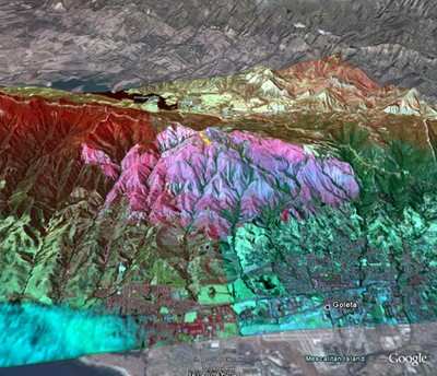
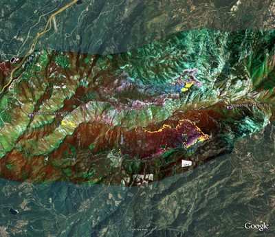
The Ikhana aircraft is imaging almost 4,000 square miles from
Santa Barbara north to the Oregon border. The flights provide
critical information about the location, size and terrain around
the fires to commanders in the field in as little as 10 minutes.
The first mission on July 8 flew over 10 individual and complex
fires along a route over the Sierra Nevada Mountains, west to the
Cub Complex fire and south to the Gap Fire in Santa Barbara
County.
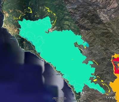
Fire images are collected onboard Ikhana and transmitted through
a communications satellite to NASA Ames. There, the imagery is
superimposed over Google Earth and Microsoft Virtual Earth maps to
better visualize the location and scope of the fires. The imagery
is then transmitted to the Multi-Agency Coordination Center in
Redding, CA, and the State Operations Center in Sacramento, which
distribute fire data to incident commanders in the field.
"Because Forest Service assets are stretched thin, NASA was
asked to provide additional resources as a supplement to existing
infrared fire imaging operations," said Jim Brass, co-principal
investigator for the Western States Fire Mission at Ames.
From a ground control center, NASA pilots are flying the
aircraft in close coordination with the Federal Aviation
Administration, which is allowing flights within the national
airspace while maintaining safe separation from other aircraft. The
FAA is allowing NASA unprecedented flexibility to fly these
missions in support of the California firefighting effort.
NASA was working with the Forest Service on a demonstration
mission later this summer, but moved up the schedule in response to
the widespread fires.
As ANN reported, the system was proven during
a series of wildfire imaging demonstration missions in August and
September 2007 and tested operationally during the Southern
California fires of October 2007.
"The NASA/Forest Service team gathered six weeks earlier than
planned because of the extreme fires in Northern California," said
Vincent Ambrosia, NASA Ames' principal investigator for the fire
mission. "The team will provide state and federal agencies with
critical fire intelligence by using NASA aircraft and
technology."
NASA's Applied Sciences and Airborne Science programs and the
Earth Science Technology Office funded development of the fire
sensor. In the hands of operational agencies, the benefits of this
NASA research and development effort can support nationwide
wildfire fighting efforts.
 Airborne-Flight Training 05.09.24: ERAU at AIAA, LIFT Diamond Buy, Epic A&P

