Mon, Jul 26, 2010
Jeppesen Charts Available Soon For Portable GPS
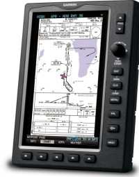
Garmin International's new and enhanced chart capabilities for
the GPSMAP 695/696 have been introduced Monday at AirVenture. This
top-of-the-line aviation portable will soon include georeferenced
Garmin FliteCharts, and cutomers also have the opportunity to
immediately subscribe to and receive Garmin’s georeferenced
ChartView powered by Jeppesen.
“We constantly solicit customer feedback in order to make
our products better, and these enhancements are a direct result of
customers’ requests for georeferenced charts,” said
Gary Kelley, Garmin’s vice president of marketing. “The
696 has a large, 7-inch portrait screen that is ideal for viewing
an entire approach plate. Now, pilots will be able to see their
aircraft’s exact position while monitoring other important
information on the approach
charts.”
Garmin FliteCharts is an electronic version of the National
Aeronautical Navigation Services Charts (AeroNav Services), which
was formerly NACO. FliteCharts lets pilots quickly find and view
all AeroNav Services Departure Procedures (DP), Standard Terminal
Arrival Routes (STARs), approach charts, and airport diagrams. If
the current approach is known, the GPSMAP 695/696 automatically
selects the correct chart based on the flight plan. Pilots will
have access to all approach plates currently published by AeroNav,
which encompasses over 15,000 charts and over 2,900 airports in the
U.S. FliteCharts updates are available from Garmin every 28 days,
and the new georeferenced capability will be included with the
regular updates.
ChartView brings an electronic version of Jeppesen’s
extensive, worldwide library of JeppView charts and airport
diagrams directly to the GPSMAP 695/696. ChartView displays
approach charts, arrival and departure procedures, and airport
diagrams.
Updates are available from Jeppesen every 14 days. The new
georeferenced version of Garmin FliteCharts will be available in
the fourth quarter 2010. FliteChart’s georeferenced support
is included in the standard FliteChart update. ChartView is
available immediately and will require a one-time additional $499
enabling key via fly.garmin.com, as well as the latest free device
software.
More News
From 2023 (YouTube Version): Legacy of a Titan Robert (Bob) Anderson Hoover was a fighter pilot, test pilot, flight instructor, and air show superstar. More so, Bob Hoover was an i>[...]
Get The Latest in Aviation News NOW on Instagram Are you on Instagram yet? It's been around for a few years, quietly picking up traction mostly thanks to everybody's new obsession >[...]
Aero Linx: B-52H Stratofortress The B-52H Stratofortress is a long-range, heavy bomber that can perform a variety of missions. The bomber is capable of flying at high subsonic spee>[...]
Altimeter Setting The barometric pressure reading used to adjust a pressure altimeter for variations in existing atmospheric pressure or to the standard altimeter setting (29.92).>[...]
"Knowing that we play an active part in bettering people's lives is extremely rewarding. My team and I are very thankful for the opportunity to be here and to help in any way we ca>[...]
 Classic Aero-TV: Remembering Bob Hoover

