Mon, Jul 26, 2010
Jeppesen Charts Available Soon For Portable GPS
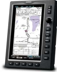
Garmin International's new and enhanced chart capabilities for
the GPSMAP 695/696 have been introduced Monday at AirVenture. This
top-of-the-line aviation portable will soon include georeferenced
Garmin FliteCharts, and cutomers also have the opportunity to
immediately subscribe to and receive Garmin’s georeferenced
ChartView powered by Jeppesen.
“We constantly solicit customer feedback in order to make
our products better, and these enhancements are a direct result of
customers’ requests for georeferenced charts,” said
Gary Kelley, Garmin’s vice president of marketing. “The
696 has a large, 7-inch portrait screen that is ideal for viewing
an entire approach plate. Now, pilots will be able to see their
aircraft’s exact position while monitoring other important
information on the approach
charts.”
Garmin FliteCharts is an electronic version of the National
Aeronautical Navigation Services Charts (AeroNav Services), which
was formerly NACO. FliteCharts lets pilots quickly find and view
all AeroNav Services Departure Procedures (DP), Standard Terminal
Arrival Routes (STARs), approach charts, and airport diagrams. If
the current approach is known, the GPSMAP 695/696 automatically
selects the correct chart based on the flight plan. Pilots will
have access to all approach plates currently published by AeroNav,
which encompasses over 15,000 charts and over 2,900 airports in the
U.S. FliteCharts updates are available from Garmin every 28 days,
and the new georeferenced capability will be included with the
regular updates.
ChartView brings an electronic version of Jeppesen’s
extensive, worldwide library of JeppView charts and airport
diagrams directly to the GPSMAP 695/696. ChartView displays
approach charts, arrival and departure procedures, and airport
diagrams.
Updates are available from Jeppesen every 14 days. The new
georeferenced version of Garmin FliteCharts will be available in
the fourth quarter 2010. FliteChart’s georeferenced support
is included in the standard FliteChart update. ChartView is
available immediately and will require a one-time additional $499
enabling key via fly.garmin.com, as well as the latest free device
software.
More News
With Testing Soon Complete, Launch Preparations Begin in Earnest Sierra Space's Dream Chaser has been put through the wringer at NASA's Glenn Armstrong Test Facility in Ohio, but w>[...]
Takeoff Roll The process whereby an aircraft is aligned with the runway centerline and the aircraft is moving with the intent to take off. For helicopters, this pertains to the act>[...]
“We’re proud of the hard work that went into receiving this validation, and it will be a welcome relief to our customers in the European Union. We couldn’t be mor>[...]
"Aircraft Spruce is pleased to announce the acquisition of the parts distribution operations of Wag-Aero. Wag-Aero was founded in the 1960’s by Dick and Bobbie Wagner in the >[...]
IDENT Feature The special feature in the Air Traffic Control Radar Beacon System (ATCRBS) equipment. It is used to immediately distinguish one displayed beacon target from other be>[...]
 Sierra Space Repositions Dream Chaser for First Mission

