Wed, Jan 22, 2014
UX5 System Designed For Aerial Imaging And Mapping
Trimble has added its UX5 unmanned aircraft system (UAS) to its Agriculture product portfolio for aerial imaging and mapping. The Trimble UX5 system can enable Ag service providers to easily capture aerial images for scouting and monitoring crop health such as detecting pests, weeds and nitrogen deficiencies. The system can locate cattle and their available forage over large areas, measure crop height, and generate topographic maps and models for land leveling and drainage applications. As a result, the system provides farmers' trusted advisors—such as agronomists, Trimble resellers, and other Ag service providers—with a powerful data collection tool that can aid with recommendations to improve farming operations.
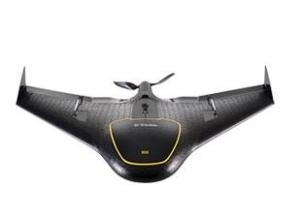
The Trimble UX5 system flies at 50 mph and is stable in significant crosswinds and even light rain. In a single 50-minute flight, the Trimble UX5 system can cover a 0.8 square mile area at two inch image resolution. It comes with a camera modified to capture the near-infrared spectrum, which helps in deducing vegetation indexes for crop health assessment. The Trimble UX5 system can capture a variety of images to be processed post flight. The output of a single flight provides geo-referenced precision images, a digital surface model (DSM) showing elevations as a color image, and a dense 3D point cloud that includes elevations.
"The addition of the Trimble UX5 system strengthens our agriculture product portfolio and enables us to provide a solution that benefits a broad range of customers including growers, ranchers, water management contractors, agronomists and other Ag service providers," said Joe Denniston, vice president of Trimble's Agriculture Division. "High-speed aerial imaging is a powerful tool that can quickly and easily locate problem areas to be addressed. The faster a problem area is discovered, the better the chance it can be evaluated and resolved before crop yield is impacted."
The Trimble UX5 system is available from Authorized Agriculture Distribution Partners and is subject to regulations and restrictions defined by local civil aviation authorities. Unmanned aircraft systems are currently not allowed to be flown in some regions or for certain applications.
(Image provided by Trimble)
More News
Also: Vertical Flight Society, NBAA Maintenance Conference, GA Honored, AMT Scholarship For the first time, students from Embry-Riddle’s Daytona Beach, Florida, campus took t>[...]
Hazardous Weather Information Summary of significant meteorological information (SIGMET/WS), convective significant meteorological information (convective SIGMET/WST), urgent pilot>[...]
"The need for innovation at speed and scale is greater than ever. The X-62A VISTA is a crucial platform in our efforts to develop, test and integrate AI, as well as to establish AI>[...]
(FAA) Inspector Observed That Both Fuel Tanks Were Intact And That Only A Minimal Amount Of Fuel Remained In Each Analysis: According to the pilot, approximately 8 miles from the d>[...]
“Pyka’s Pelican Cargo is unlike any other UAS solution on the market for contested logistics. We assessed a number of leading capabilities and concluded that the Pelica>[...]
 Airborne-Flight Training 05.09.24: ERAU at AIAA, LIFT Diamond Buy, Epic A&P

