Airmate EFB Adds Synthetic Vision | Aero-News Network
Aero-News Network
RSS icon RSS feed
podcast icon MP3 podcast
Subscribe Aero-News e-mail Newsletter Subscribe

Airborne Unlimited -- Most Recent Daily Episodes

Episode Date

Airborne-Monday

Airborne-Tuesday

Airborne-Wednesday Airborne-Thursday

Airborne-Friday

Airborne On YouTube

Airborne-Unlimited-04.29.24

Airborne-Unlimited-04.23.24

Airborne-Unlimited-04.24.24 Airborne-FltTraining-04.25.24

Airborne-Unlimited-04.26.24

Wed, Jun 15, 2022

Airmate EFB Adds Synthetic Vision

Popular Flight Planning & Weather App Ups Capability

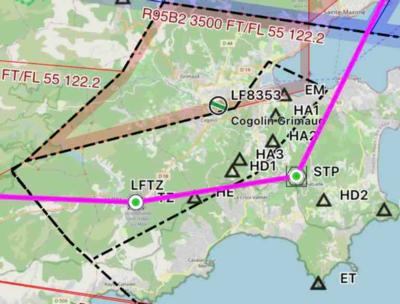
Airmate EFB, the free, flight-planning and weather app, now offers synthetic vision. The feature is provided free of charge to Airmate users. Formerly, synthetic vision capability required a premium subscription plan.

The Airmate app is compatible with iPhone, iPad, and Android phone or tablets. User inputs and data are synced with Airmate Web Flight Planning, thereby permitting users to flight-plan at home and fly with their devices. Data can also be shared among devices. 

Airmate displays an EFIS/AHRS view, showing all flight parameters—to include the new, synthetic vision feature, which bases its depictions on a worldwide terrain database. The system can be used with either computer flight simulators or actual aircraft. In the latter instance, AHRS data are obtained from iOS accelerometers, onboard avionics, or an external ADS-B receiver. By providing the synthetic vision feature, Airmate seeks to increase flight safety by augmenting pilots’ situational awareness.

The app embeds worldwide ICAO VFR charts and official IFR High and Low enroute charts (provided by national AIP authorities). The charts, which may be downloaded free of charge, are geo-referenced, and can be overlaid on top of the Airmate moving map display.

Airmate users may also view and utilize VFR and IFR airport approach plates and SIDs / STARs procedures in more than 200 countries. 

The aforementioned navigational charts and approach aids derive of an AIRAC database sourced from FAA, Eurocontrol and numerous national authorities. Airmate supplements the database with information pertaining to peripheral landmarks and facilities such as unlicensed, or ultralight airfields. The database is updated—free of charge to Airmate users—at every AIRAC cycle.

In addition to flight-planning and aeronautical navigation data, Airmate grants users access to meteorological utilities such as: NOAA/FAA METAR, TAF, SIGMET, satellite charts, and radar/rainfall maps. 

FMI: www.airmate.aero

Advertisement

More News

ANN's Daily Aero-Term (04.26.24): DETRESFA (Distress Phrase)

DETRESFA (Distress Phrase) The code word used to designate an emergency phase wherein there is reasonable certainty that an aircraft and its occupants are threatened by grave and i>[...]

Aero-News: Quote of the Day (04.26.24)

"General aviation is at the forefront of developing and introducing innovative technologies that will transform the entire aviation industry..." Source: Kyle Martin, Vice President>[...]

ANN's Daily Aero-Term (04.27.24): Direct

Direct Straight line flight between two navigational aids, fixes, points, or any combination thereof. When used by pilots in describing off-airway routes, points defining direct ro>[...]

ANN's Daily Aero-Linx (04.27.24)

Aero Linx: Women in Corporate Aviation Women in Corporate Aviation support individuals seeking career advancement and professional development in the business aviation industry. Me>[...]

Aero-News: Quote of the Day (04.27.24)

“We would like to thank the many volunteers that help throughout the year to pull off the event, as well as the several reviewers, judges, and SURVICE staff that provide team>[...]

blog comments powered by Disqus


Advertisement

Advertisement

Podcasts

Advertisement

© 2007 - 2024 Web Development & Design by Pauli Systems, LC