Drones To Seek Out Surviving Koalas In Bushfire Zones | Aero-News Network
Aero-News Network
RSS icon RSS feed
podcast icon MP3 podcast
Subscribe Aero-News e-mail Newsletter Subscribe

Airborne Unlimited -- Most Recent Daily Episodes

Episode Date

Airborne-Monday

Airborne-Tuesday

Airborne-Wednesday Airborne-Thursday

Airborne-Friday

Airborne On YouTube

Airborne-Unlimited-04.29.24

Airborne-Unlimited-04.23.24

Airborne-Unlimited-04.24.24 Airborne-FltTraining-04.25.24

Airborne-Unlimited-04.26.24

Tue, Mar 24, 2020

Drones To Seek Out Surviving Koalas In Bushfire Zones

Queensland University Of Technology Using Infrared Imaging To Search For The Animals

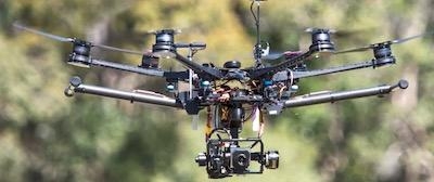
Queensland University Of Technology (QUT) researchers will apply their innovative method for detecting koalas using drones and infrared imaging in a collaborative project to identify wildlife populations in bushfire affected areas.

Associate Professor Grant Hamilton has joined with Noosa and District Landcare to launch a project that will use technology and artificial intelligence to create a “census” of animals that survived the bushfires. “We know that the devastating bushfires have had a terrible impact on wildlife, but in order to help protect those which survived the terrible disaster we first need to identify the populations of animals that are still in fire affected areas,” Professor Hamilton said.

Last year, Professor Hamilton  co-authored a study with PhD student Evangeline Corcoran and Dr Simon Denman from QUT, and John Hanger and Bree Wilson from Endeavour Veterinary Ecology,  that was published in Nature journal Scientific Reports, that detailed a technique for locating koalas using drones that can detect heat signatures.

The researchers created an algorithm that was designed to identify the heat signatures of koalas, which can be very difficult to spot from ground level. Noosa and District Landcare acting general manager Rachel Lyons said the recent bushfires affected koala habitat in the Noosa region at Peregian Springs, Weyba Downs, Doonan and Cooroibah. “The main burn zones were very intense with full canopy fires, flanking areas and back burn sites varied in intensity,” Ms. Lyons said.

“Koalas were unlikely to have survived the canopy fire areas and we have held concerns about the survival of koalas in the less intense sites.

“Koalas have been rescued within the areas post-fire as a result of concerns for health and food availability.”

Professor Hamilton said the Sunshine Coast research project was the first in what could be a wider study of koala populations in bushfire affected areas. Professor Hamilton is currently in discussions with other animal welfare groups to carry out drone surveys for koalas in other areas. “We are also working on ways to extend our algorithm to automatically detect other species likely to be found in the areas,” Professor Hamilton said. “Last year, we were able to show that our system for detecting koalas was more accurate than using expert observers.

“Another advantage of using drones to spot animals from the air is that we can cover areas much quicker than people on foot can conduct a search, and we can cover areas that are too inaccessible for spotters on the ground.”

The researchers will begin their drone survey of the Noosa region fire areas as soon as cooler morning temperatures better allow for the heat sensing drone cameras to detect koalas by their heat signatures.

(Image provided with QUT news release. Images from QUT YouTube video)

FMI: www.qut.edu.au

Advertisement

More News

Unfortunate... ANN/SportPlane Resource Guide Adds To Cautionary Advisories

The Industry Continues to be Rocked By Some Questionable Operations Recent investigations and a great deal of data has resulted in ANN’s SportPlane Resource Guide’s rep>[...]

ANN FAQ: Turn On Post Notifications

Make Sure You NEVER Miss A New Story From Aero-News Network Do you ever feel like you never see posts from a certain person or page on Facebook or Instagram? Here’s how you c>[...]

ANN's Daily Aero-Term (04.29.24): Visual Approach Slope Indicator (VASI)

Visual Approach Slope Indicator (VASI) An airport lighting facility providing vertical visual approach slope guidance to aircraft during approach to landing by radiating a directio>[...]

ANN's Daily Aero-Term (04.28.24): Airport Marking Aids

Airport Marking Aids Markings used on runway and taxiway surfaces to identify a specific runway, a runway threshold, a centerline, a hold line, etc. A runway should be marked in ac>[...]

ANN's Daily Aero-Linx (04.28.24)

Aero Linx: The Skyhawk Association The Skyhawk Association is a non-profit organization founded by former Skyhawk Pilots which is open to anyone with an affinity for the A-4 Skyhaw>[...]

blog comments powered by Disqus


Advertisement

Advertisement

Podcasts

Advertisement

© 2007 - 2024 Web Development & Design by Pauli Systems, LC