GTN PC Trainer Also Upgraded With New Capabilities
EASA has approved Garmin's new high-end flight deck technologies, as well as Connext and VFR Manual Charts, which are now available for the GTN 650/750 touchscreen avionics. This new update provides options such as custom holding patterns and search and rescue patterns, as well as animated NEXRAD radar, fuel range ring display, RF leg approach support and more. New and existing customers can receive these features by contacting an authorized Garmin dealer. Additionally, the GTN PC Trainer has been updated to reflect these new capabilities within the GTN series and is available as a free download.
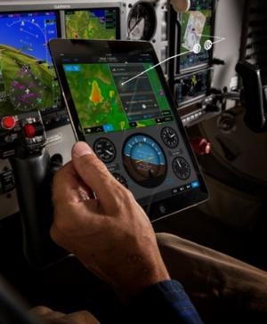
The GTN now offers wireless cockpit connectivity featuring Connext when incorporating the Flight Stream 210 wireless gateway, which has also received EASA approval. With this, GTN customers have access to wireless flight plan transfer capabilities when using Garmin Pilot on an iOS mobile device. Connext cockpit connectivity gives pilots the ability to transfer completed flight plans within Garmin Pilot to the GTN upon arrival at the airport, allowing more time to focus on pre-flight activities. Additionally, active flight plans that are manually amended in-flight may be sent between the GTN and Garmin Pilot so flight plans are identical and amendments only need to be made on one device. Furthermore, GPS information from the GTN series and attitude information from the Flight Stream 210, combine to display within Garmin Pilot. The Flight Stream 210 is available immediately for $999.
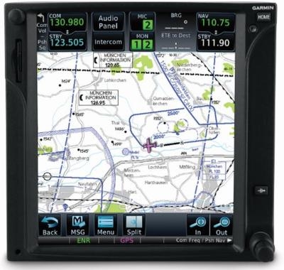
VFR Manual Charts (formerly known as Bottlang charts) are now available from Jeppesen, which can be downloaded and displayed on the GTN 750 series. These charts contain color-coded visual approach, landing and area charts, as well as general and country-related text sections, including regulations, communications, meteorology and more. Similar to IFR charts, these VFR charts can be overlaid on the moving map or displayed on the dedicated chart page. Access to these charts requires a Jeppesen subscription.
Pilots now have the flexibility to quickly build customized holding patterns within the GTN 650/750. These holds may be created over an existing fix in the navigation database, over a user-defined waypoint and inserted into a flight plan or via direct-to navigation. Additionally, pilots may input an Expect Further Clearance (EFC) time, which populates a message on the GTN as a reminder to depart the hold or contact ATC.
Garmin is pleased to offer radius-to-fix (RF) leg support within a retrofit navigator, providing customers with additional instrument approach options. With the GTN touchscreen series and a digital horizontal situation indicator (HSI), (including the G500 or G600 flight displays), pilots can now fly RF leg types, which can be found in complex Instrument Approach Procedures (IAPs). Additional instrument approach enhancements include the option to load a secondary approach during the missed approach segment, so pilots have ample time to prepare for the next approach sequence. For added situational awareness, waypoints prior to the final approach fix (FAF) are also displayed when selecting a vectors-to-final (VTF) transition.
Flight planning is easier with FastFind, which incorporates predictive logic to suggest airports and waypoints using current GPS location. Quick flight plan entry is possible with FastFind, which automatically begins searching for the nearest identifier as an airport or waypoint is entered within a flight plan.
Weather-related decision-making is easier with the GTN 650/750, which helps pilots interpret the trend of datalink radar more easily by animating imagery received from the GSR 56 via Iridium.
Popular among Garmin’s Integrated Flight Deck product line, the GTN series can now overlay a fuel range ring overtop the moving map, displaying the remaining flight distance for the given amount of fuel on board. Aircraft range until operating on reserve fuel and total endurance are displayed as a green dashed line and yellow solid line, respectively.
For operators conducting SAR missions, the GTN 650/750 can automatically generate flight plans using four search patterns: Parallel Line Search, Expanding Square, Orbit or Sector Search patterns. SAR is available as an option and aids in crew situational awareness during these missions by streamlining the process of entering, managing and flying search patterns. Additionally, SAR patterns can be flown by a compatible autopilot so pilots can more easily focus on the task at hand.
These new features are available from Garmin Authorized Dealers for hundreds of aircraft makes and models (installation and optional feature charges may apply) and is EASA approved for installation under standard documentation, saving time and added expense.
(Images provided with Garmin news release)
 Unfortunate... ANN/SportPlane Resource Guide Adds To Cautionary Advisories

