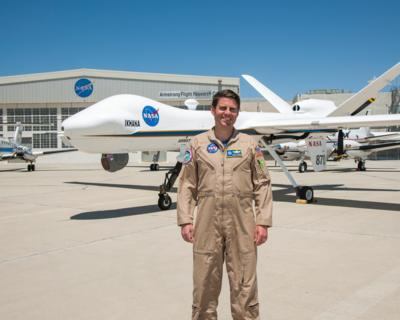
Howe Began Assisting National Guard Wildfire Monitoring During The 2018 Fire Season
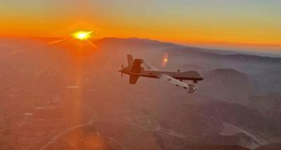
NASA pilot Scott Howe is flying a remotely piloted MQ-9 with infrared cameras that can see through smoke and ash. The live images are overlaid with maps and satellite imagery of California wildfires to give commanders a more complete picture of what they face. Howe is not flying the Ikhana, a civilian variant of the MQ-9 that was based at NASA’s Armstrong Flight Research Center in California. This fire season he has often been flying a MQ-9 for the California Air National Guard as they assist with some of the most devastating wildfires in the state’s history.
At the height of operations, there were about 18,700 firefighters battling 27 wildfires, nearly 2,400 fire engines are deployed, 129 aircraft were assigned and more than 360 bulldozers plowed fire lines critical to stopping the fire’s movement.
Howe began assisting National Guard wildfire monitoring during the 2018 fire season. He supported a few missions last year and has been very active this year. In fact, for the first time the National Guard has flown as many as three MQ-9 aircraft simultaneously to assist with fires that are located through the entire state.
He flies from a ground station based at March Air Reserve Base in Riverside County in California. In Howe’s 13 years with his unit called the Grizzlies, this was the first time the entire unit was involuntarily mobilized. He has tallied about three weeks of flying so far and another eight days on alert since the worst of the crisis began around Labor Day.
The aircraft flies between 20,000-26,000 feet altitude as part of the conditions of a certificate of authorization (COA) with the Federal Aviation Administration granted to fly the missions. That process and early fire mission demonstrations were assisted by NASA Armstrong and the now retired remotely piloted Ikhana during the 2006 Western States Fire Mission.
His most intense experience this summer was supporting the Bobcat fire in the San Gabriel Mountains.
“The fire looked like a claw, or a tiger paw stretching south out of the mountains right up to a neighborhood in the Azusa area. “It literally was right in the backyard of these homes. It seemed like there was a firetruck parked in everyone’s driveway, every single home, ready to do whatever it took to defend each house. I really felt the urgency of what we were doing.”
Howe and his unit give fire commanders vital information about the fire’s hot spots and provide maps of the fires to strategically protect people, firefighters and property. His unit has another important job.
“There’s also the side benefit of noticing if a floating ember started a new spot fire way off that nobody has caught,” he explained.
During the El Dorado fire that was in the Oak Glen (in San Bernardino, California) area he barely believed the convective heat coming from the fire and how tall the flames were. Howe also observed the grit and bravery of the firefighters.
“I saw fire trucks parked at the bottom of this steep slope on a fire access road,” he said. “Firefighters had hiked hose sections uphill hundreds of feet in elevation in rugged terrain toward the fire.”
Howe saw a number of examples of how fast a fire moves when he was observing the Zogg fire near Redding and Eureka in Northern California.
“If there is a small smoldering fire, sometimes those trees may have enough moisture where they don’t easily burn,” he explained. “However, when you get to the hottest part of the fire, the flames are three times higher than the tallest pine trees.”
That’s why he said evacuation orders are important.
“The fire also can move in a straight line, whereas the roads are confined to the twisty layout of the terrain. When an evacuation order is given, it can’t be predicted if a person waits if he or she might find their escape route cut off by the fire. When it gets to that intense state, there’s not much you can do.”
Because of the need for more missions, Howe had more responsibility this fire season flying portions of the missions in addition to the takeoff and landing support.
“I was able to see all aspects of the mission,” he said. “There are so many fires, so spread out through the entire state, separated by 100s of miles,” Howe said.
The Cal Fire team schedules a day in advance so when pilots start their shifts, they know where they are going.
“The big work for the pilot is not just putting the aircraft in a good position looking at a particular fire with the way the terrain can mask things, which is what you are doing when you are on station, when they need you to move, you have to build a whole flight plan and clearance to move that aircraft to a new location.”

Multiple target areas are slated for the two to three hour block. The shifts are nine hours and have a day, mid shift and swing shift. He reports for his shift an hour before he is scheduled to complete paperwork to fly, monitor feeds from the aircraft and attend the mission briefing including fires updates and statewide weather.
The pilots are assigned to a ground cockpit and given the mission assignment. Once seated in the ground cockpit, Howe usually can remove his mask required when people can’t socially distance. A plexiglass barrier between him and the sensor operator he is paired with in the other seat, receive an update briefing and the pilots switch seats when it is their opportunity to fly.
“We continue to update information as we go,” he added. “We have a white board next to each of the stations so that it is easy to track the mission and use that information to brief the next flight crew.”
Usually a rest period follows to get something to eat, check emails and complete office work. Typically, a pilot will fly two blocks during a nine hour shift if the unit is busy.
Regardless of the task, Howe is ready to help.
 ANN's Daily Aero-Term (04.30.24): Runway Centerline Lighting

