Controller Broadcast AIRMETs for IFR And Mountain Obscuration, Turbulence And Freezing Levels
Location: Bishop, GA Accident Number: ERA20FA118
Date & Time: 03/03/2020, 1634 EST Registration: N43368
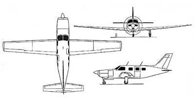
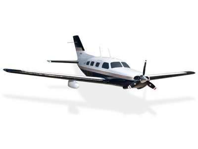
Aircraft: Piper PA46 Injuries: 3 Fatal

On March 3, 2020, about 1634 eastern standard time, a Piper PA-46-310P, N43368, was destroyed when it was involved in an accident near Bishop, Georgia. The pilot and two passengers were fatally injured. The airplane was operated as a Title 14 Code of Federal Regulations Part 91 personal flight.
The pilot filed an instrument flight rules (IFR) flight plan and was in contact with air traffic control (ATC) shortly after departure from Columbia Metropolitan Airport (CAE), Columbia, South Carolina, at 1529. A review of the ATC communications and radar data provided by the Federal Aviation Administration revealed that the airplane was on a westerly track from CAE, about 6,000 ft mean sea level (msl), en route to Tuscaloosa Regional Airport (TCL), Tuscaloosa, Alabama. The pilot contacted the Atlanta Terminal Radar Approach Control (TRACON) about 1613, and was provided the current altimeter setting. The controller also broadcast AIRMETs for IFR and mountain obscuration, turbulence and freezing levels.
About 1616, the controller advised the pilot that the flight would need to go north or south over Atlanta. After a few seconds, the pilot advised north, and also said that he could fly at a higher altitude as well. The controller advised the pilot that flying over Atlanta's airspace probably would not work, but he would try and get him as close as possible. The controller subsequently issued a new clearance to the pilot, which included two intersections on the north side of Atlanta, and then direct to TCL.
About 1621, the pilot requested to deviate left for weather, the controller approved the request and advised the pilot he would be past the line of weather in about 15-20 miles. About 1629, the controller advised the pilot there was a gap in the line of weather in about 8 miles with light precipitation, that he would turn him north to get through it, and once north of the weather the pilot could proceed on course.
About 1630, the controller instructed the pilot to fly a heading of 300°. The pilot acknowledged, then a few seconds later advised that heading was directly toward a convective cell that was "pretty big." The controller explained that he would be keeping him south of the heavy precipitation and turning him north through the line where there was currently about 3 miles of light precipitation. The pilot then stated that the area seemed to be closing in fast. The
controller acknowledged and advised him that alternatively he would need to fly south around Atlanta, and the pilot then stated that he would turn right. The controller advised the pilot to fly a 300° heading that would keep the airplane out of the moderate precipitation. The pilot stated "I thought I was gonna shoot this gap here, I got a gap I can go straight through." The controller acknowledged and advised that was fine if it looked good to him, but that he showed moderate precipitation starting in about 1 mile extending for about 4 miles north bound; the pilot acknowledged.
About 1633 the controller asked the pilot what his flight conditions were, the pilot responded, "rain three six eight." There were no further transmissions from the pilot. A witness stated he was about a 1/2 mile from the accident site and observed scattered rain showers in the area, the base of the clouds were about 2,500 to 3,000 ft, and there was no lightning or thunder. He heard engine noise and then saw the airplane spinning towards the ground in a nose low attitude until it disappeared from sight. He did not see any parts separate from the airplane. He arrived on scene a few minutes later; he stated the fuselage was directly below where he saw the airplane spinning, and it was engulfed in flames.
A second witness stated he heard the airplane, turned and looked up to see it tilted left with its nose pointed towards the ground. He saw the airplane for a few seconds, it was about 150 ft above the ground and spun once or twice. He believed that both wings were attached, and he did not see anything separate from the airplane. He heard the engine revving up and down, then "heard a loud crash." He stated that it was raining heavily right after the accident.
Radar returns from the airplane ended at the western edge of an east-west oriented line of severe thunderstorms and rain showers.
The airplane impacted a wooded area behind a residential property at an elevation of 760 ft and the main wreckage was oriented on a magnetic heading of 090°. All major components were accounted for at the scene. The main wreckage consisted of the fuselage and engine. The wings, empennage, and airframe components were located along the 1/2 mile long debris path.
The right side of the fuselage was destroyed by a postimpact fire. The primary flight control cables were traced from the cockpit area to their respective flight control surfaces through impact and overload separation areas.
A borescope was utilized to examine the engine cylinders; all intake and exhaust valves were intact. Crankshaft and valve continuity were confirmed from the front to the rear of the engine.
Both magnetos were rotated through the impulse coupling and exhibited a spark on all lead outputs. The two-bladed propeller remained attached to the engine, both blades were free of leading edge gouges or chord-wise scratches.
The postaccident examination of the airframe and engine revealed no evidence of mechanical malfunctions or failures that would have precluded normal operation.
 Unfortunate... ANN/SportPlane Resource Guide Adds To Cautionary Advisories

