Parrot Introduces Two New Drones At The Commercial UAV Expo | Aero-News Network
Aero-News Network
RSS icon RSS feed
podcast icon MP3 podcast
Subscribe Aero-News e-mail Newsletter Subscribe

Airborne Unlimited -- Most Recent Daily Episodes

Episode Date

Airborne-Monday

Airborne-Tuesday

Airborne-Wednesday Airborne-Thursday

Airborne-Friday

Airborne On YouTube

Airborne-Unlimited-04.29.24

Airborne-Unlimited-04.23.24

Airborne-Unlimited-04.24.24 Airborne-FltTraining-04.25.24

Airborne-Unlimited-04.26.24

Thu, Oct 26, 2017

Parrot Introduces Two New Drones At The Commercial UAV Expo

Bluegrass, Bebop-Pro Thermal Intended For Specific Missions

Parrot has introduced two new mission-specific drones at the Commercial UAV Expo being held this week in Las Vegas.

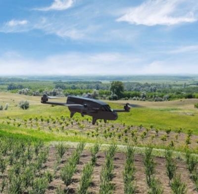
According to the company blog, the Parrot Bluegrass is the first Parrot quadcopter specifically designed for agriculture and is the latest business solution from Parrot, joining and complementing the Parrot Professional range. The Parrot Bebop-Pro Thermal is an all-in-one quadcopter thermal imaging solution, specifically designed for small construction businesses, thermal inspection professionals and public safety services.

Parrot Bluegrass is a multipurpose drone that helps farmers improve their ROI, using its 2 embedded cameras; video camera and multispectral sensor. This solution facilitates the visual monitoring of the farm’s infrastructure. It also provides a quick and easy analysis on the health of their crops, thanks to the easy to use processing software, AIRINOV FIRST+.

The AIRINOV FIRST+ online platform enables users to process and analyze the data and images captured by Parrot Sequoia.

In just a few hours, the farmer receives a turnkey report composed of orthomosaic NDVI maps (absolute and adjusted) and zoning (simple and detailed). This provides a precise view of the biomass (density of vegetation) and relative health of the crops, helping professionals to determine which areas need specific attention. Professionals can use these insights to understand which areas require the most maintenance and track the effects and evolution of the farm with high precision.

With Parrot Bluegrass, farmers and agriculture cooperatives keep the control of the data captured by the quadcopter and the analysis of these data is directly delivered to them, with no intermediary.

The Bluegrass can automatically cover up to 74 acres at 230 ft. flight altitude per battery use. It can also fly at low altitudes, optimizing crops that may require precise mapping.

Parrot Bebop-Pro Thermal is a quadcopter that allows architects, builders, roofers and real estate agencies to safely carry out inspections with its 2 embedded cameras, enabling the operator to make videos and take pictures of buildings and roofs in visual or thermal images, quickly providing an overview and identifying major thermal losses.

The new FreeFlight Thermal mobile app provides live streaming and recording of both the visual and thermal images.

The Bluegrass is expected to retail for about $5,900, excluding VAT. No price was given for the Bebop-Pro Thermal.

(Image provided with Parrot blog post)

FMI: Blog Post, www.parrot.com/us/business-solutions

Advertisement

More News

Unfortunate... ANN/SportPlane Resource Guide Adds To Cautionary Advisories

The Industry Continues to be Rocked By Some Questionable Operations Recent investigations and a great deal of data has resulted in ANN’s SportPlane Resource Guide’s rep>[...]

ANN FAQ: Turn On Post Notifications

Make Sure You NEVER Miss A New Story From Aero-News Network Do you ever feel like you never see posts from a certain person or page on Facebook or Instagram? Here’s how you c>[...]

ANN's Daily Aero-Term (04.29.24): Visual Approach Slope Indicator (VASI)

Visual Approach Slope Indicator (VASI) An airport lighting facility providing vertical visual approach slope guidance to aircraft during approach to landing by radiating a directio>[...]

ANN's Daily Aero-Term (04.28.24): Airport Marking Aids

Airport Marking Aids Markings used on runway and taxiway surfaces to identify a specific runway, a runway threshold, a centerline, a hold line, etc. A runway should be marked in ac>[...]

ANN's Daily Aero-Linx (04.28.24)

Aero Linx: The Skyhawk Association The Skyhawk Association is a non-profit organization founded by former Skyhawk Pilots which is open to anyone with an affinity for the A-4 Skyhaw>[...]

blog comments powered by Disqus


Advertisement

Advertisement

Podcasts

Advertisement

© 2007 - 2024 Web Development & Design by Pauli Systems, LC