Thu, Apr 06, 2017
John Deere Operations Center Users Can Now Securely Access Same-Day Drone Data In The Field
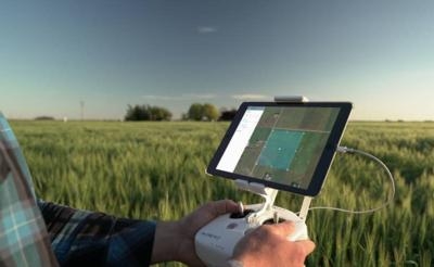
DroneDeploy, the leading drone data platform for businesses, is now connected with the John Deere Operations Center. Just in time for the critical spring planting season, the integration allows users to synchronize their DroneDeploy and MyJohnDeere accounts to view and analyze drone-generated field maps in combination with other important crop data in Operations Center.
Data analytics and automation technology, including drone mapping, offer the potential to improve efficiency and increase yields by helping growers optimize crop performance and deploy resources like water, pesticides and fertilizers where they will be most effective. Since its inception in 2013, DroneDeploy has seen the ag industry come to the forefront of commercial drone adoption as growers increasingly rely on drone mapping to collect intelligence and drive decision-making.
Individual farmers and growers who are using Operations Center can now connect their accounts to DroneDeploy to:
- Import field boundaries from Operations Center for easy drone flight planning
- Capture, view and annotate drone maps
- Export DroneDeploy maps and insights into Operations Center
"The beauty of integrating DroneDeploy with John Deere Operations Center, is that it allows me to take a look at the data that comes from drone and compare against application data, yield from combine and historical data," said eff Buyck, owner and operator of Buyck Farms in Balaton, Minn. and Integrated Solutions Manager at C & B Operations. "I can easily share this data with crop consultants and advisors and use it to make more informed decisions throughout the year."
"Growers all over the world are embracing next-generation tools such as self-driving tractors and ag robots to improve operations and yields. Likewise, our drone software and sophisticated ecosystem of third-party apps have been proven to streamline farming tasks," said Scott Lumish, Vice President of Business Development at DroneDeploy. "The new John Deere API integration -- which comes on the heels of several of other recent ag industry announcements, signifies our continued commitment to providing ag professionals a one-stop solution to access drone data in the field."
Thousands of farmers and growers are already leveraging DroneDeploy's drone data intelligence platform and tools available on the DroneDeploy App Market to improve crop yields and farming operations year-round:
- Crop Scout to Detect Parasites and Fungi: Growers from California to Missouri have used DroneDeploy's drone mapping to see areas of rust fungus in wheat crops, to spot small (and hard-to-pinpoint) patches of parasitic dodder in alfalfa fields, and more.
- Compile Plant Counts: During the 2016 growing season, a private farm in Northern California used AgriSens, a third-party tool within the DroneDeploy dashboard, to quickly get a plant count report of hundreds of thousands of tomatoes plants on a 74-acre field.
- Analyze Crop Emergence and Stand Establishment: Growers of corn and soybean (both commodities closely scrutinized by global markets) and other crops are sending DroneDeploy maps to analytics company Aglytix, to create a report that details stand establishment of newly planted crops throughout an entire field. More comprehensive than on-the-ground sampling, the report also includes a stand establishment index and a calculation of economic loss on the field.
- Assess and Clean Up Damage After Storms: Instead of relying on traditional ground scouting, which can miss large portions of downed crop, growers are using DroneDeploy for detailed same-day Skymatics reports that capture a complete picture and generate calculated crop loss.
(Source: Drone Deploy news release)
More News
Runway Lead-in Light System Runway Lead-in Light System Consists of one or more series of flashing lights installed at or near ground level that provides positive visual guidance a>[...]
Aero Linx: Aviation Without Borders Aviation Without Borders uses its aviation expertise, contacts and partnerships to enable support for children and their families – at hom>[...]
Dave Juwel's Aviation Marketing Stories ITBOA BNITBOB ... what does that mean? It's not gibberish, it's a lengthy acronym for "In The Business Of Aviation ... But Not In The Busine>[...]
From 2010 (YouTube Version): Yeah.... This IS A Really Cool Job When ANN's Nathan Cremisino took over the lead of our Aero-TV teams, he knew he was in for some extra work and a lot>[...]
Also: Junkers A50 Heritage, Montaer Grows, Dynon-Advance Flight Systems, Vans' Latest Officially, the Carbon Cub UL and Rotax 916 iS is now in its 'market survey development phase'>[...]
 ANN's Daily Aero-Term (04.24.24): Runway Lead-in Light System

