The Answer, My Friend, is …
As a matter of convention, Remotely Piloted Aircraft (RPA)—colloquially, drones—measure wind-speed, direction, and cumulative effect by dint of onboard flow-sensors. Data so gathered informs the operators of such platforms and enhances the safety of both close-range and Beyond Visual Line Of Sight (BVLOS) flights.

A group of Embry-Riddle researchers, however, is attempting to leverage GPS for purpose of gleaning more accurate and reliable wind information.
Embry-Riddle associate professor of mechanical engineering Dr. Marc Compere, in collaboration with Doctors and professors of aeronautical science Kevin Adkins and Avinash Muthu Krishnan, recently described a novel means by which to measure wind effects in the international, peer-reviewed Drones journal.
Dr. Compere set forth: “The GPS method does not attempt to estimate thrust or drag forces. Using only GPS and orientation sensors, our new strategy estimates wind vectors in an Earth-fixed frame during turning maneuvers.”
Dr. Adkins added: “It's all about safety. The lower atmosphere is a new and incredibly dynamic portion of the environment for sustained aviation operations; traditionally, this is an area we have passed through quickly during ascent and descent. Wind poses unique challenges to controllability and the aircraft’s range and endurance.”
The named researchers collectively aspire to render Unmanned Aerial System (UAS) operations more predictable, thereby hastening the advent of markets such as drone package-delivery and Urban Air Mobility (UAM) while contributing to the larger evolution of the Advanced Air Mobility (AAM) sector.
Dr. Compere opined: “People flying in electric aircraft like the Jetsons — no kidding, that’s in our near future, perhaps in the next decade.”
The salience of anemometry extends well beyond UAS operations. By way of example, the study of atmospheric conditions and air quality are predicated largely upon accurate wind measurements. Terrestrially, wind data is essential to the comprehension of wildfires and the combatting of such.
“Sensing wind is a critical part of society that not many people are aware of,” Compere noted.
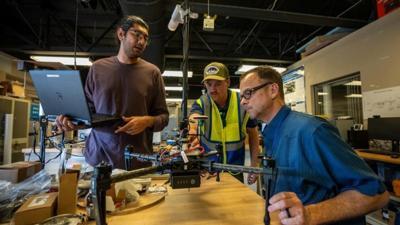
About eight students enrolled in Embry-Riddle’s Colleges of Aviation and Engineering assisted Drs. Compere, Adkins, and Krishnan, the latter of whom stated: “Working on research is predominantly what made me want to keep furthering my education. Research is easily the most effective way to gain practical experience and knowledge. Concepts may seem simple when learned in a classroom, but having to practically execute the concept is often quite a challenge.”
Dr. Krishnan added: “Students should never be afraid to ask a professor to join their research. Not only is it a great way to boost your resume with practical experience, but it also is a good way to meet like-minded individuals.”
Student-researcher Jeremy Copenhaver agreed with Krishnan, asserting: “The experience of working with an elite team and helping develop and confirm new wind data is fascinating. Down the road, I want to apply UAS to industry field applications to help develop new solutions for existing problems, as well as help push the technology into new fields.”
Dubbed the Wind-Arc Method, the praxis espoused by Compere et al. is not new. The Embry-Riddle research team, however, has made the tactic more viable through the incorporation of computer simulations. Specialized software is used to forecast flight conditions—to include aircraft heading, airspeed, and wind speed trends—then produce real-time statistics indicative of an aircraft’s likely responses to nuanced changes to its flight environment.
Dr. Compere averred: “The very nature of wind makes it a difficult quantity to measure, but our simulation provides an ability that no experimental approach can provide: We can simulate wind with exact known inputs and test the method with exact known outputs.”
Currently, the team is collecting weather data by means of expensive, custom-built aircraft outfitted with onboard flow sensors. The process is complex and time-consuming. By invoking GPS technology, a standard feature of commercial drones, the antecedent problems are dramatically mitigated.
“Scaling and simplicity is what measuring wind with just a GPS and a compass provides,” Dr. Compere conceded. “All drones already have these sensors. They’re built-in from the factory.”
Dr. Adkins pointed out the GPS approach opens the possibility of crowdsourcing weather data from multiple users at once, stating: “The sheer number of potential observations can produce a far superior product, especially in urban environments where things change more quickly. The use of GPS makes both business and safety sense.”
Seeking to advance the evolution of technologies germane to drone-delivery, the research team formerly simulated UAS routes along Embry-Riddle’s Daytona Beach campus. Also, they utilized UAS to monitor and improve air quality. In time, Compere and his contemporaries hope to commercialize the Wind-Arc Method. A patent is reportedly pending.

Dr. Krishnan enthused: “Now that we see the need and understand the base concept, we want to grow it further, publish more, dig deeper into the original idea and expand it to different applications.”
Currently, the research team is installing a new weather station atop a light pole on the university’s Daytona Beach campus. Designed specifically for drone-based atmospheric testing, the station will feature an anemometer capable of measuring wind speed and velocity in three directions. Data deriving of subject anemometer will serve as a reference datum against which researchers will verify data recorded by UAS.
“It’s fancy and awesome,” Dr. Compere remarked of the station. “To get scientifically valid measurements, the data collected by those mobile sensors need to be validated against a stable reference instrument.”
Compere concluded: “This is how we will continue to publish high-quality journal and conference papers with scientifically valid wind measurements.”
 Airborne 05.10.24: Icon Auction, Drunk MedEvac Pilot, Bell ALFA

