Fri, Apr 10, 2015
A NextGen Aviation App That Provides Graphical Weather, Traffic, And Textual Data
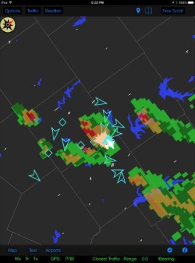
FreeFlight Systems announces the release of ADS-B View 2.0 - a free NextGen aviation iPad app that provides graphical weather, traffic, and textual data to the aircraft pilot and crew. Weather and traffic information is received by the RANGR ADS-B system, transmitted to the tablet via WiFi, and overlayed on the ADS-B View map.
"As with the previous version, and in keeping with the 'Free Weather and Traffic' philosophy of ADS-B, the app is available free of charge from the Apple store and works with any FreeFlight Systems ADS-B In system," said Tim Taylor, President and CEO of FreeFlight Systems.
The graphical weather can be placed into a looping mode so that weather changes can be viewed over time. The map can be configured to show runways, roads, lakes, and state and county lines. Bookmarks allow the user to easily return to previously viewed areas. The user can select a freely-scrollable map view, or have the aircraft remain centered on the map either North-up or Track-up. In addition, textual information, such as METARs, is provided.
ADS-B View version 2.0 offers the ability for user selection of an ownship position source, a new graphics engine, and additional support. Selection of an ownship position source allows users with an installed RANGR system to use the internal WAAS/GPS to drive the position source on their iPad. Users also have the option choose external Bluetooth GPS data depending on personal preference.
The new graphics engine provides increased responsiveness to user interaction, including smoother scrolling and full map rotation capability. Additional connectivity support allows for fewer disruptions when connectivity between the tablet and the transceiver is poor. It also enables multiple tablets to connect to the same transceiver, which was not supported by ADS-B View 1.0.
ADS-B View can be downloaded from the Apple App Store. Current ADS-B View users simply need to update their existing app to receive the benefits of the newest version.
(Image provided by FreeFlight Systems)
More News
Airport Marking Aids Markings used on runway and taxiway surfaces to identify a specific runway, a runway threshold, a centerline, a hold line, etc. A runway should be marked in ac>[...]
"It is extremely difficult, if not impossible, for manned aircraft to see a drone while conducting crop-enhancing and other aerial applications at low altitudes and high speeds. We>[...]
Aero Linx: The Skyhawk Association The Skyhawk Association is a non-profit organization founded by former Skyhawk Pilots which is open to anyone with an affinity for the A-4 Skyhaw>[...]
“The T-54A benefits from an active Beechcraft King Air assembly line in Wichita, Kansas, where all required METS avionics and interior modifications are installed on the line>[...]
Aero Linx: Aerostar Owners Association The Association offers the Aerostar Owner a unique opportunity to tap an invaluable source of information concerning the care and feeding of >[...]
 ANN's Daily Aero-Term (04.28.24): Airport Marking Aids

