Global Data-Driven Aeronautical Maps, New And Expanded Planning And Filing Capabilities On Mobile And The Web, Logbook Enhancements, And More
The latest version of ForeFlight has hit the app stores, and there are lots of new features in this newest release.
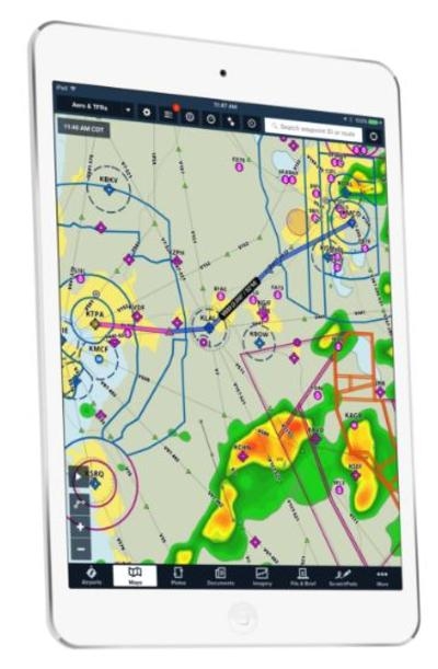
For a start, there are the Global Data-Driven Aeronautical Maps ...ForeFlight’s Aeronautical Maps available on mobile and the web ... feature incredibly fast Continuous Zoom technology and dynamic decluttering, powered by a completely rebuilt map engine.
Aeronautical Maps smoothly render and scale when panning and zooming without having to load or refresh. Map elements and text simply fade in and out without losing clarity or legibility as the zoom level is adjusted. Dynamic 'always-up' labels make it easy to read the map from any orientation.
ForeFlight Aeronautical Maps is offered in the Basic Plus, Pro Plus, and Business Pro plans.
Useful Information At Every Zoom Level
Never lose the details to see the big picture—the right information is there at any zoom level. For example, when viewing the entire United States, major airports and ARTCC boundaries are shown; as you zoom in, Bravo airspace, VORs, waypoints, airways, and smaller airports materialize.
Smart Airway Labels make efficient use of the space between waypoints on an airway. As you zoom in, the labels dynamically expand to display magnetic bearing and the MEA.
Embedded Airport Diagrams
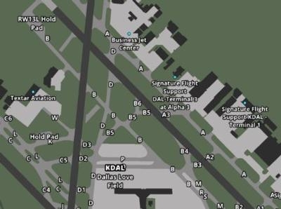
Zoom in to an airport and something amazing happens—the airport diagram appears on its own, complete with runway and taxi labels and even FBO locations. These are the same ForeFlight diagrams that you've come to know in the app, and which now allow you to see aircraft ownship directly on the map without having to open the published airport chart.
Aeronautical Maps Look Stunning on the Web
ForeFlight on the web makes it easier than ever to plan, file, and brief, manage aircraft profiles, generate Logbook reports, view Track Logs, and access account management functions—all in a beautifully designed desktop experience.
ForeFlight Aeronautical Maps is offered in our Basic Plus, Pro Plus, and Business Pro plans.
Route Editor, NavLog, & Route Advisor
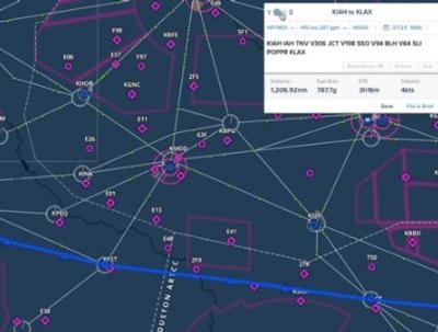
Familiar Route Editor and Navlog views make it easy to build and edit a route using text input or rubber band planning. ForeFlight’s auto-complete search engine returns results as fast as you type based on waypoints, navaids, airport names, routes, and city names. Just like on Mobile, Route Advisor allows you to simply enter departure and destination identifiers into the Route Editor, then select from available route suggestions including airway, recently cleared ATC routes, preferred routes, or TEC routes.
File & Brief On The Web
All of the same file and brief features you enjoy on ForeFlight Mobile are now available via the web. You can amend and cancel IFR plans and activate and close VFR plans –and it's all instantly synced to your mobile devices. ForeFlight’s Graphical Briefing transforms the standard text briefing information and delivers it in a visually elegant design for better readability – and it looks amazing in the full desktop view.
Logbook Gives Rise to an Ecosystem

ForeFlight Logbook is more than just an electronic record of your flights. It's an interconnected ecosystem of pilot tools and services that makes it as easy as possible for you to maintain an accurate and current record of your flying by connecting your personal logbook with other services you rely on.
(Images provided with ForeFlight online announcement)
 Unfortunate... ANN/SportPlane Resource Guide Adds To Cautionary Advisories

