Arcturus UAV And Urban Robotics Fly 3-D Imager | Aero-News Network
Aero-News Network
RSS icon RSS feed
podcast icon MP3 podcast
Subscribe Aero-News e-mail Newsletter Subscribe

Airborne Unlimited -- Most Recent Daily Episodes

Episode Date

Airborne-Monday

Airborne-Tuesday

Airborne-Wednesday Airborne-Thursday

Airborne-Friday

Airborne On YouTube

Airborne-Unlimited-04.29.24

Airborne-NextGen-04.30.24

Airborne-Unlimited-05.01.24 Airborne-AffordableFlyers--05.02.24

Airborne-Unlimited-05.03.24

Tue, Jan 28, 2014

Arcturus UAV And Urban Robotics Fly 3-D Imager

Device Can Create 3-D Images In Near-Real Time, Maker Says

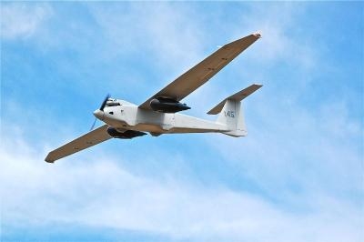
A sensor system designed to create 3-D reconstructions in near-real time and output high-resolution digital elevation models, LIDAR-like datasets, and wide area maps has been flown on an Arcturus UAV T-20 Tier II unmanned aerial vehicle. The system, called GeoDragon, is enclosed in a wing-mounted pod and is capable of high resolution 2-D and 3-D image capture.

Urban Robotics in Portland, OR, which designed the sensor, says among its "unique aspects" are low weight (equating to longer endurance and loiter time,) small operational footprint on the ground (1 or 2 full size pick-up trucks,) a quick mount/dismount pod, quiet operation (the T-20 utilizes a modified 4-stroke engine,) and the ability to fly simultaneously with other payloads on the T-20, such as EO/IR.

GeoDragon imagery is post-processed using automated 3-D algorithms to rapidly generate large mapping and modeling datasets. Urban Robotics develops software and hardware solutions for 3-D ISR, remote sensing and geospatial applications, including collection, post-processing, and data management. 

The aircraft was built by Arcturus UAV in Rohnert Park, CA. Urban Robotics says the GeoDragon adds significant 3-D imaging and mapping capabilities to the T-20 UAV. The system is scheduled to be released in mid-2014.

(Image provided by Arcturus)

FMI: www.arcturus-uav.com

Advertisement

More News

ANN's Daily Aero-Term (05.01.24): Say Altitude

Say Altitude Used by ATC to ascertain an aircraft's specific altitude/flight level. When the aircraft is climbing or descending, the pilot should state the indicated altitude round>[...]

ANN's Daily Aero-Linx (05.01.24)

Aero Linx: European Air Law Association (EALA) EALA was established in 1988 with the aim to promote the study of European air law and to provide an open forum for those with an int>[...]

Classic Aero-TV: Korean War Hero Twice Reborn

From 2023 (YouTube Version): The Life, Death, Life, Death, and Life of a Glorious Warbird In 1981, business-owner Jim Tobul and his father purchased a Chance-Vought F4U Corsair. Mo>[...]

Airborne 04.29.24: EAA B-25 Rides, Textron 2024, G700 Deliveries

Also: USCG Retires MH-65 Dolphins, Irish Aviation Authority, NATCA Warns FAA, Diamond DA42 AD This summer, history enthusiasts will have a unique opportunity to experience World Wa>[...]

Airborne Affordable Flyers 05.02.24: Bobby Bailey, SPRG Report Cards, Skydive!

Also: WACO Kitchen Bails, French SportPlane Mfr to FL, Dynon-Advance Flight Systems, Innovation Preview Bobby Bailey, a bit of a fixture in sport aviation circles for his work with>[...]

blog comments powered by Disqus


Advertisement

Advertisement

Podcasts

Advertisement

© 2007 - 2024 Web Development & Design by Pauli Systems, LC