Precision Aerial Using UAS To Survey Drainage System In Texas | Aero-News Network
Aero-News Network
RSS icon RSS feed
podcast icon MP3 podcast
Subscribe Aero-News e-mail Newsletter Subscribe

Airborne Unlimited -- Most Recent Daily Episodes

Episode Date

Airborne-Monday

Airborne-Tuesday

Airborne-Wednesday Airborne-Thursday

Airborne-Friday

Airborne On YouTube

Airborne-Unlimited-05.13.24

Airborne-NextGen-05.14.24

Airborne-Unlimited-05.15.24 Airborne-AffordableFlyers-05.16.24

Airborne-Unlimited-05.17.24

Fri, Feb 02, 2018

Precision Aerial Using UAS To Survey Drainage System In Texas

Evaluating Conditions Following Hurricane Harvey

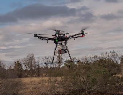
Precision Aerial Compliance Solutions, LLC (Precision Aerial), in partnership with The Woodlands Joint Powers Agency (WJPA) is providing drone LiDAR surveying for portions of The Woodlands drainage system in response to Hurricane Harvey. “The WJPA, on behalf of the Municipal Utility Districts it represents, is taking proactive steps now to help improve drainage during future rainstorms,” said James M. Stinson, PE, general manager for the WJPA.

The WJPA is the central management agency for the ten Municipal Utility Districts (MUDs) that serve The Woodlands in Montgomery County. To evaluate current conditions along portions of Panther Creek and Spring Creek, Precision Aerial will utilize high-end, drone LiDAR to provide the laser assessment for the WJPA. Deploying one of the few drones in the country capable of this type of survey, this will be the first look of its kind at the drainage systems to evaluate current conditions and consider improvements for future preventive measures.

“This is the first use of drone LiDAR by a city or local governmental agency for a drainage survey in Texas and possibly in the whole country,” said Scott McGowan, President, Precision Aerial. “We are uniquely qualified to provide this type of service not only because of our experience, but we operate one of the few drones in the country capable of actually performing this type of scanning. Our cutting-edge LiDAR systems are setting a new industry standard for accuracy and efficiency, and it is something very special.”

Precision Aerial, a Conroe-based aerial data collection and inspection service company, is a member of the LJA Engineering family.

(Image provided with LJA Engineering news release)

FMI: www.lja.com

Advertisement

More News

Bolen Gives Congress a Rare Thumbs-Up

Aviation Governance Secured...At Least For a While The National Business Aviation Association similarly applauded the passage of the FAA's recent reauthorization, contentedly recou>[...]

The SportPlane Resource Guide RETURNS!!!!

Emphasis On Growing The Future of Aviation Through Concentration on 'AFFORDABLE FLYERS' It's been a number of years since the Latest Edition of Jim Campbell's HUGE SportPlane Resou>[...]

Buying Sprees Continue: Textron eAviation Takes On Amazilia Aerospace

Amazilia Aerospace GmbH, Develops Digital Flight Control, Flight Guidance And Vehicle Management Systems Textron eAviation has acquired substantially all the assets of Amazilia Aer>[...]

Hawker 4000 Bizjets Gain Nav System, Data Link STC

Honeywell's Primus Brings New Tools and Niceties for Hawker Operators Hawker 4000 business jet operators have a new installation on the table, now that the FAA has granted an STC f>[...]

Echodyne Gets BVLOS Waiver for AiRanger Aircraft

Company Celebrates Niche-but-Important Advancement in Industry Standards Echodyne has announced full integration of its proprietary 'EchoFlight' radar into the e American Aerospace>[...]

blog comments powered by Disqus


Advertisement

Advertisement

Podcasts

Advertisement

© 2007 - 2024 Web Development & Design by Pauli Systems, LC