Thu, Jun 25, 2015
Incorporates Helicopter Route Charts In Major U.S. Cities
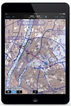
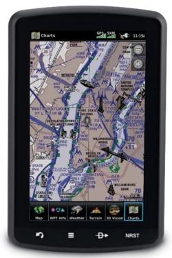
Garmin now support the display of helicopter route charts throughout the United States, as well as Canadian IFR and VFR sectional charts on select products. The aera 795/796, G3X Touch and Garmin Pilot for iOS now support the display of these charts with the most recent system software installed.
Additionally, helicopter route charts are available for these products throughout eight U.S. metropolitan areas, including the Gulf of Mexico, which provide highly detailed map information tailored to helicopter operators.
NAV CANADA aeronautical chart coverage is now available throughout Canada, providing valuable information such as radio frequencies, airspace boundaries, landmark information and more. These charts are available for G3X Touch and the aera 795/796 starting at $39.99.
Garmin Pilot Canada Premium is available in the iTunes store for $129.99 annually and includes access to these new charts, as well as comprehensive navigation information, FliteCharts terminal procedures and SafeTaxi airport diagrams for Canada.
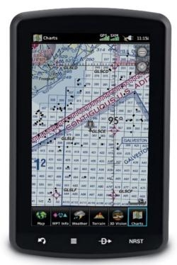
Helicopter route charts are also available for the aera 795/796, G3X Touch and Garmin Pilot, which provide and display information tailored to helicopter operators and their unique operations. These three-color charts depict helicopter airways and routes, heliports with associated frequency and lighting capabilities, NAVAID information and obstructions. Additionally, pictorial symbols, roads and geographical features are notated on these charts for easier identification in urban areas with high concentrations of helicopter activity.
VFR and IFR Helicopter Route Charts are available for eight major metropolitan areas within the U.S., including:
- Baltimore-Washington
- Boston
- Chicago
- Dallas-Ft.Worth
- Detroit
- Houston
- Los Angeles
- New York
Coverage for the Gulf of Mexico is also available, which includes offshore oil drilling platforms and more.
Helicopter route charts are currently available and included within the IFR/VFR charts database starting at $39.99 for G3X Touch and the aera 795/796. G3X Touch customers must update to software version 3.70 or later and aera 795/796 customers must update to software version 4.60 or later to access these charts. Helicopter operators have access to these charts within the latest version of Garmin Pilot, which is available immediately as a free update for existing customers. For new customers, Garmin Pilot is available in the Apple App Store as a free download for the first 30 days. After the 30-day trial period, customers may purchase an annual subscription of Garmin Pilot Canada Premium starting at $129.99.
(Images provided by Garmin)
More News
Very High Frequency The frequency band between 30 and 300 MHz. Portions of this band, 108 to 118 MHz, are used for certain NAVAIDs; 118 to 136 MHz are used for civil air/ground voi>[...]
Aero Linx: Aviation Suppliers Association Established February 25, 1993, the Aviation Suppliers Association (ASA), based in Washington, D.C., is a not-for-profit association, repre>[...]
Have A Story That NEEDS To Be Featured On Aero-News? Here’s How To Submit A Story To Our Team Some of the greatest new stories ANN has ever covered have been submitted by our>[...]
From 2021 (YouTube Version): Colorado Campus Offers aVariety Of Aerospace Entertainment And Education Wings over the Rockies Exploration of Flight is the second location for the Wi>[...]
Also: Paramotor Champ's, Electric Ultralight, ICON BK Update, Burt Rutan at Oshkosh! The Popular Rotorcraft Association is reaching out for help in rebuilding their private runway >[...]
 ANN's Daily Aero-Term (05.17.24): Very High Frequency

