Jeppesen Unveils New Logo, Product At AirVenture 2008 | Aero-News Network
Aero-News Network
RSS icon RSS feed
podcast icon MP3 podcast
Subscribe Aero-News e-mail Newsletter Subscribe

Airborne Unlimited -- Most Recent Daily Episodes

Episode Date

Airborne-Monday

Airborne-Tuesday

Airborne-Wednesday Airborne-Thursday

Airborne-Friday

Airborne On YouTube

Airborne-Unlimited-04.29.24

Airborne-Unlimited-04.23.24

Airborne-Unlimited-04.24.24 Airborne-FltTraining-04.25.24

Airborne-Unlimited-04.26.24

Tue, Jul 29, 2008

Jeppesen Unveils New Logo, Product At AirVenture 2008

New VFR+GPS Nav Chart Billed As "Perfect VFR Chart"

Jeppeson unveiled its new corporate logo reflecting the evolution of its products and services, as well as its expansion into all transportation markets. Known for its aeronautical navigational products, now they offer an array of solutions for land and sea operations as well.

The logo is known as The Edge. The transition from an airplane silhouette into a series of stacked shapes represents Jeppesen's forward movement. Mark Van Tine, Jeppesen president and CEO, says, "I believe our new logo communicates the image we want the people to embrace when they think of Jeppesen... for our long-standing aviation customers, the message is that we are much more than 'just that old chart company.'"

In the coming months, the logo will be rolled out across its products and in a new website, currently under development.

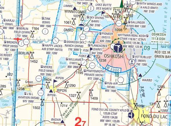
Jeppesen also announced the release of the new VFR+GPS charts for navigation in North America. Initially developed in Europe many years ago, it is a clean-sheet design. Incorporating color and contrast to make a VFR chart easier to read and interpret, it also adds GPS elements, such as all airport identifiers and GPS waypoints.

The depiction of Class B, C, D and E airspace is much more easily understood, with altitude limits clearly shown. Data from NAVTEQ provides the latest information on roads, cities, and points of interest easily identified from the air. Terrain data from the Space Shuttle radar missions provide a realistic depiction of the earth below. State-of-the-art charting tools combine the data for a clean, intuitive look. JeppGuide airport diagrams are on the back of each chart.

Christopher Dean, product manager for business and general aviation at Jeppesen, briefed the media on the new charts. "The new charts were designed by pilots for pilots," says Dean. "It's the perfect VFR chart."

The new coverage areas will initially include enroute and area charts from Miami to Atlanta. Launch kits will be sent to area FBOs next week. Expansion to other areas across the lower 48 states of the US will be completed by late 2009. The latest enroute chart offered covers Wisconsin and Illinois, which will be featured as a Special Oshkosh Commemorative Chart during AirVenture at the Jeppesen booth.

The initial cost of the charts will be $9.95 for the enroute charts and $5.95 for the area charts. A digital rollout will occur once all the North American charts are completed.

FMI: www.jeppesen.com

Advertisement

More News

ANN's Daily Aero-Term (04.30.24): Runway Centerline Lighting

Runway Centerline Lighting Flush centerline lights spaced at 50-foot intervals beginning 75 feet from the landing threshold and extending to within 75 feet of the opposite end of t>[...]

ANN's Daily Aero-Linx (04.30.24)

Aero Linx: Air Force Global Strike Command Air Force Global Strike Command, activated August 7, 2009, is a major command with headquarters at Barksdale Air Force Base, Louisiana, i>[...]

Airborne 04.24.24: INTEGRAL E, Elixir USA, M700 RVSM

Also: Viasat-uAvionix, UL94 Fuel Investigation, AF Materiel Command, NTSB Safety Alert Norges Luftsportforbund chose Aura Aero's little 2-seater in electric trim for their next gli>[...]

Airborne 04.29.24: EAA B-25 Rides, Textron 2024, G700 Deliveries

Also: USCG Retires MH-65 Dolphins, Irish Aviation Authority, NATCA Warns FAA, Diamond DA42 AD This summer, history enthusiasts will have a unique opportunity to experience World Wa>[...]

Airborne-NextGen 04.23.24: UAVOS UVH 170, magni650 Engine, World eVTOL Directory

Also: Moya Delivery Drone, USMC Drone Pilot, Inversion RAY Reentry Vehicle, RapidFlight UAVOS has recently achieved a significant milestone in public safety and emergency services >[...]

blog comments powered by Disqus


Advertisement

Advertisement

Podcasts

Advertisement

© 2007 - 2024 Web Development & Design by Pauli Systems, LC