Harris Delivers Advanced Environmental Monitoring Sensor For Japanese Satellite | Aero-News Network
Aero-News Network
RSS icon RSS feed
podcast icon MP3 podcast
Subscribe Aero-News e-mail Newsletter Subscribe

Airborne Unlimited -- Most Recent Daily Episodes

Episode Date

Airborne-Monday

Airborne-Tuesday

Airborne-Wednesday Airborne-Thursday

Airborne-Friday

Airborne On YouTube

Airborne-Unlimited-04.29.24

Airborne-NextGen-04.30.24

Airborne-Unlimited-05.01.24 Airborne-AffordableFlyers--05.02.24

Airborne-Unlimited-05.03.24

Fri, Jun 22, 2018

Harris Delivers Advanced Environmental Monitoring Sensor For Japanese Satellite

GOSAT-2 Will Increase Ability To Measure Greenhouse Gases From Space

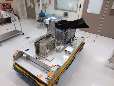
Harris Corporation has delivered an environmental monitoring sensor for the Greenhouse Gases Observing Satellite-2 (GOSAT-2), which will significantly enhance Japan’s ability to monitor greenhouse gases from space.

The Harris-built TANSO-FTS-2 (Thermal and Near Infrared Sensor for Carbon Observation-Fourier Transform Spectrometer-2) will measure greenhouse gases in the atmosphere. The newly built instrument will collect high-spectral resolution data of the Earth in five bands, which enables measurement during daylight and darkness. The instrument’s unique intelligent pointing system identifies, in real time, cloud-free areas of the atmosphere – greatly increasing the amount of useable data.

Harris provided the sensor to Mitsubishi Electric Corporation, which is building the satellite for the Japanese Aerospace Exploration Agency. The satellite is scheduled to launch in Japan’s 2018 fiscal year.

“GOSAT is the cornerstone of Japan’s space-based climate program,” said Roberto Mitrevski, vice president and general manager, Harris Environmental Solutions. “The Harris instrument will provide Japan with improved measurement capability and positions us well for follow-on GOSAT and other missions.”

This represents the third instrument Harris has delivered to Japan in recent years, including two advanced imagers for the Himawari-8 and 9 weather satellites, which launched in 2014 and 2016.

(Image provided with Harris Corporation news release)

FMI: www.harris.com

Advertisement

More News

ANN's Daily Aero-Term (05.02.24): Touchdown Zone Lighting

Touchdown Zone Lighting Two rows of transverse light bars located symmetrically about the runway centerline normally at 100 foot intervals. The basic system extends 3,000 feet alon>[...]

Aero-News: Quote of the Day (05.02.24)

“Discovery and innovation are central to our mission at Virgin Galactic. We’re excited to build on our successful record of facilitating scientific experiments in subor>[...]

Aero-News: Quote of the Day (05.03.24)

"We are reaching out to you today on behalf of the Popular Rotorcraft Association because we need your help. We are dangerously close to losing a critical resource that if lost, wi>[...]

ANN's Daily Aero-Term (05.03.24): UAS Traffic Management (UTM)

UAS Traffic Management (UTM) The unmanned aircraft traffic management ecosystem that will allow multiple low altitude BVLOS operations and which is separate from, but complementary>[...]

ANN's Daily Aero-Linx (05.03.24)

Aero Linx: Society of Aviation and Flight Educators (SAFE) SAFE is a member-oriented organization of aviation educators fostering professionalism and excellence in aviation through>[...]

blog comments powered by Disqus


Advertisement

Advertisement

Podcasts

Advertisement

© 2007 - 2024 Web Development & Design by Pauli Systems, LC