Garmin Pilot Adds Obstacles And Terrain For Android | Aero-News Network
Aero-News Network
RSS icon RSS feed
podcast icon MP3 podcast
Subscribe Aero-News e-mail Newsletter Subscribe

Airborne Unlimited -- Most Recent Daily Episodes

Episode Date

Airborne-Monday

Airborne-Tuesday

Airborne-Wednesday Airborne-Thursday

Airborne-Friday

Airborne On YouTube

Airborne-Unlimited-05.13.24

Airborne-NextGen-05.07.24

Airborne-Unlimited-05.08.24 Airborne-FlightTraining-05.09.24

Airborne-Unlimited-05.10.24

Wed, Jun 24, 2015

Garmin Pilot Adds Obstacles And Terrain For Android

Overlays For VFR Sectionals, IFR Charts

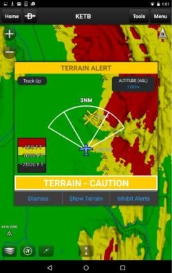
An updated version of the Garmin Pilot app for Android, which incorporates the display of both terrain and obstacles overtop Garmin’s rich, dynamic navigation maps, VFR Sectionals, IFR high and low enroute charts, is now available. These terrain and obstacle overlays display visual alerts of potential hazards and enhance situational awareness, particularly in unfamiliar environments.

In addition to terrain and obstacles, version 4.3 for Android supports X-Plane 10 and other compatible simulators, offers the option to display density altitude information and now includes a new subscription options.

Garmin Pilot version 4.3 provides pilots with the option to overlay terrain and obstacles simultaneously on the moving map page, while retaining the ability to view pertinent in-flight navigation information. Terrain and obstacle information can be overlaid and viewed in track-up format, ensuring flight plan information is upright and easy to read. Pilots also have access to a dedicated terrain page, so they may view terrain and obstacles in an arc or 360-degree view. 
 
With a premium upgrade, intuitive colors incorporated within Garmin Pilot help pilots easily discern their proximity relative to terrain. Pilots are provided visual caution or warning alerts when operating near obstacles or terrain that may be of potential conflict. Terrain data leverages highly detailed data found within Garmin avionics and portables and is available in various resolutions to provide pilots the flexibility to select the level of detail they prefer for their device.

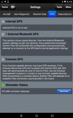
Garmin Pilot now supports X-Plane 10, as well as a variety of other compatible simulators. Customers may launch X-Plane and connect Garmin Pilot to the simulator. Once the connection is made, Garmin Pilot conveniently sends AHRS information to display flight plan information within the application and the simulator.

Pilots can optionally display density altitude information within Garmin Pilot in the METAR widget. By viewing widgets in split screen mode, density altitude is calculated and displayed to provide pilots information that is critical to aircraft performance.

The features of the upgraded packages have been enhanced to include visual and aural terrain and obstacle alerting.

New packages include:

  • VFR Premium - $49.99 annually, which adds geo-referenced SafeTaxi diagrams along with terrain and obstacle alerts
  • IFR Premium - $74.99 annually, includes features within VFR Premium along with geo-referenced FliteCharts

The latest version of Garmin Pilot for Android is available immediately in the U.S. as a free update for existing Garmin Pilot subscribers. For new customers, Garmin Pilot is available in the Google Play store as a free trial for the first 30 days.

(Images provided by Garmin)

FMI: www.garmin.com/apps


Advertisement

More News

Bolen Gives Congress a Rare Thumbs-Up

Aviation Governance Secured...At Least For a While The National Business Aviation Association similarly applauded the passage of the FAA's recent reauthorization, contentedly recou>[...]

The SportPlane Resource Guide RETURNS!!!!

Emphasis On Growing The Future of Aviation Through Concentration on 'AFFORDABLE FLYERS' It's been a number of years since the Latest Edition of Jim Campbell's HUGE SportPlane Resou>[...]

Buying Sprees Continue: Textron eAviation Takes On Amazilia Aerospace

Amazilia Aerospace GmbH, Develops Digital Flight Control, Flight Guidance And Vehicle Management Systems Textron eAviation has acquired substantially all the assets of Amazilia Aer>[...]

Hawker 4000 Bizjets Gain Nav System, Data Link STC

Honeywell's Primus Brings New Tools and Niceties for Hawker Operators Hawker 4000 business jet operators have a new installation on the table, now that the FAA has granted an STC f>[...]

Echodyne Gets BVLOS Waiver for AiRanger Aircraft

Company Celebrates Niche-but-Important Advancement in Industry Standards Echodyne has announced full integration of its proprietary 'EchoFlight' radar into the e American Aerospace>[...]

blog comments powered by Disqus


Advertisement

Advertisement

Podcasts

Advertisement

© 2007 - 2024 Web Development & Design by Pauli Systems, LC