Thu, Mar 08, 2012
ICAO-Compliant Digital Terrain And Obstacle Data Now Available Worldwide
An agreement between GE Aviation and GeoEye will make ICAO-compliant terrain and obstacle aeronautical data derived from GeoEye’s high resolution Earth imagery available to the aviation industry. GE is showcasing this technology at ATC Global this week in Amsterdam.
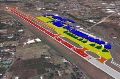
As the first offering under this agreement, GE will provide ICAO Annex 15 Area-2 terrain and obstacle databases to support the development of new Performance-based Navigation (PBN) flight paths around the world. This digital, highly detailed terrain and obstacle mapping, collected by some of the world’s highest-resolution commercial earth-imaging satellites, will support the world's airport, airlines and aviation authorities as they move to adopt PBN.
“This advanced aeronautical data, along with our Required Navigation Performance (RNP) products, will accelerate the deployment of RNP flight paths that will help meet the global challenge of increasing efficiency in the world's air traffic management system,” said Giovanni Spitale, general manager of GE’s PBN Services. “It will allow the benefits of PBN to be achieved earlier for the global air transportation community - saving time, fuel, reducing emissions and noise while increasing hourly operations frequency and maintaining safety.”
Additional GE Aviation offerings under the agreement will support advanced terrain and obstacle visualization, surface guidance through airport mapping databases (AMDB), pilot simulator training and flight operations quality assurance (FOQA) replay. Avionics providers, airlines, and ANSPs will benefit from access to accurate and current real world views of critical topography, obstacles and airport details.
“Over the next decade, we will eventually provide this aeronautical data for hundreds of airports in the world,” continued Spitale. “This will become the reference geospatial database for the aviation community.” (Image provided by GE Avaition)
More News
Aero Linx: Model Aeronautical Association of Australia MAAA clubs are about fun flying, camaraderie and community. For over 75 years, the MAAA has been Australia’s largest fl>[...]
Touchdown Zone Lighting Two rows of transverse light bars located symmetrically about the runway centerline normally at 100 foot intervals. The basic system extends 3,000 feet alon>[...]
“Discovery and innovation are central to our mission at Virgin Galactic. We’re excited to build on our successful record of facilitating scientific experiments in subor>[...]
How To Get A Story On Aero-TV News/Feature Programming How do I submit a story idea or lead to Aero-TV? If you would like to submit a story idea or lead, please contact Jim Campbel>[...]
Student Pilot Reported That During Rotation, “All Of A Sudden The Back Of The Plane Kicked To The Right..." Analysis: The student pilot reported that during rotation, “>[...]
 ANN's Daily Aero-Linx (05.02.24)

