Aviation Mobile Apps Launches GPS Coordinate Converter | Aero-News Network
Aero-News Network
RSS icon RSS feed
podcast icon MP3 podcast
Subscribe Aero-News e-mail Newsletter Subscribe

Airborne Unlimited -- Most Recent Daily Episodes

Episode Date

Airborne-Monday

Airborne-Tuesday

Airborne-Wednesday Airborne-Thursday

Airborne-Friday

Airborne On YouTube

Airborne-Unlimited-05.13.24

Airborne-NextGen-05.14.24

Airborne-Unlimited-05.15.24 Airborne-AffordableFlyers-05.16.24

Airborne-Unlimited-05.17.24

Sun, Sep 18, 2016

Aviation Mobile Apps Launches GPS Coordinate Converter

Converts Coordinates Between Standard Formats, Measures Distance And Bearing To Locations

A new app for iOS mobile devices has been introduced to give pilots a "faster and simpler" way to convert coordinates mid-flight, among other powerful functions.

The GPS Coordinate Converter from Aviation Mobile Apps can be downloaded now from the Apple App Store.

"This is the highest quality coordinate converter on the market today," says Aviation Mobile Apps Founder Bill DeWeese. "It measures distance and bearing, and includes a database of airports and radio navigation aids, a smart keyboard, bookmarks, and a built-in user guide."

The company says GPS Coordinate Converter is an advanced tool designed to do one job extremely well – convert coordinates between all the major formats. These include latitude and longitude, decimal degrees, degrees-minutes-seconds, degrees and decimal minutes, UTM, ARINC 424, and FMS. The app is especially useful for pilots on oceanic flights, where receiving coordinates in several different formats is common. Pilots can use GPS Coordinate Converter to convert data relayed by an air traffic controller to a format accepted by their flight computer.

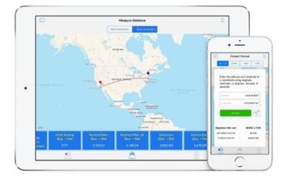
The distance and bearing feature of GPS Coordinate Converter places both coordinates on a map, tracing a line between them showing the shortest route. The app naturally accounts for the curvature of the Earth. Initial distance and bearing is measured in several formats simultaneously: nautical miles, nautical miles UK, kilometers or statute miles. When an Internet connection is available, the app can even provide time zone and postal code data for coordinates.

Perhaps the most innovative feature of GPS Coordinate Converter is its smart keyboard, which is designed exclusively for working with geographic coordinates, the company said. The app understands and adapts to the context of different coordinate formats. Only the keys that make sense at each position are active, which prevents many common data entry errors. Should the user hit an inactive key, the app will suggest which type of entry should be made instead.

"Our specialized keyboard makes it easy to do the right thing and hard to do the wrong thing," remarks DeWeese. "And yes, copy and paste works, too."

Users can save and recall frequently used coordinates with GPS Coordinate Converter's bookmark feature. Coordinates are saved locally in any format rather than in the cloud, so network strength is never an issue. Users can rearrange saved data to suit their needs. "Delete" and "Delete All" commands are also available.

A searchable database makes it quick and easy to find the coordinates of airports and navigation aids around the world. Complete postal addresses are provided when applicable. Database contents include not only airports, but also heliports, seaplane bases, VOR/VORTAC stations, NDB stations and DME stations.

(Images provided with Aviation Mobile Apps news release)

FMI: http://gpscoordinateconverter.com

Advertisement

More News

Bolen Gives Congress a Rare Thumbs-Up

Aviation Governance Secured...At Least For a While The National Business Aviation Association similarly applauded the passage of the FAA's recent reauthorization, contentedly recou>[...]

The SportPlane Resource Guide RETURNS!!!!

Emphasis On Growing The Future of Aviation Through Concentration on 'AFFORDABLE FLYERS' It's been a number of years since the Latest Edition of Jim Campbell's HUGE SportPlane Resou>[...]

Buying Sprees Continue: Textron eAviation Takes On Amazilia Aerospace

Amazilia Aerospace GmbH, Develops Digital Flight Control, Flight Guidance And Vehicle Management Systems Textron eAviation has acquired substantially all the assets of Amazilia Aer>[...]

Hawker 4000 Bizjets Gain Nav System, Data Link STC

Honeywell's Primus Brings New Tools and Niceties for Hawker Operators Hawker 4000 business jet operators have a new installation on the table, now that the FAA has granted an STC f>[...]

Echodyne Gets BVLOS Waiver for AiRanger Aircraft

Company Celebrates Niche-but-Important Advancement in Industry Standards Echodyne has announced full integration of its proprietary 'EchoFlight' radar into the e American Aerospace>[...]

blog comments powered by Disqus


Advertisement

Advertisement

Podcasts

Advertisement

© 2007 - 2024 Web Development & Design by Pauli Systems, LC