Parrot And Survae Announce Partnership | Aero-News Network
Aero-News Network
RSS icon RSS feed
podcast icon MP3 podcast
Subscribe Aero-News e-mail Newsletter Subscribe

Airborne Unlimited -- Most Recent Daily Episodes

Episode Date

Airborne-Monday

Airborne-Tuesday

Airborne-Wednesday Airborne-Thursday

Airborne-Friday

Airborne On YouTube

Airborne-Unlimited-05.13.24

Airborne-NextGen-05.14.24

Airborne-Unlimited-05.15.24 Airborne-AffordableFlyers-05.16.24

Airborne-Unlimited-05.17.24

Mon, Mar 16, 2020

Parrot And Survae Announce Partnership

Will Pair Enterprise Drone Imagery With Interactive Mapping

European drone group Parrot and Survae, a software platform for managing aerial and ground-based imagery, have launched a partnership through Parrot’s SDK program to combine Parrot’s ANAFI and ANAFI Thermal hardware and Survae’s software for professional drone use.

Parrot’s ANAFI and ANAFI Thermal drones offer an ultra-compact tool for professionals, helping them gain new vantage points to make informed decisions using the drone’s aerial insights. In addition to its built-in 4K HDR camera, ANAFI Thermal also integrates a FLIR thermal sensor— allowing working professionals to easily capture thermal and visual readings for faster response times, along with higher precision and efficiency.

Survae is a next-generation software platform helping enterprise, government and NGOs to visualize and understand places and events by automating video and image processing from a wide range of ground-based and aerial cameras. The company’s cloud-based platform incorporates video, images and sensor data into interactive maps and timelines, providing geospatial and temporal context to organize data so it can be easily searched, visualized, and explored.

Through Survae’s platform, all data is automatically connected to a map and timeline and every frame of the video and imagery is geolocated, date and time stamped. The company’s visual search engine enables users to quickly find relevant data and watch video or images from any point on the map. All video and imagery can be easily shared with Survae’s interactive video/map player, as well.

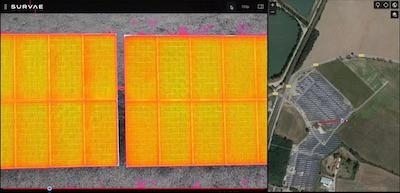
As part of the new partnership, Parrot ANAFI and ANAFI Thermal drone users can submit visible and thermal videos directly to the Survae platform for easy-access and enhanced footage organization.

“This collaboration is the latest in Parrot’s SDK Partner program,” said Jerome Bouvard, Director of Strategic Partnerships at Parrot. “We are supporting the development of an ecosystem of solutions to meet the unique needs of Parrot’s professional drone users. Survae offers novel capabilities for visualizing and providing context for ANAFI video in both space and time.”

Through its SDK Partner program, Parrot is working with partners to create new professional applications, software and hardware that seamlessly integrate with Parrot ANAFI and ANAFI Thermal drones.

“We have been very impressed by the ANAFI Thermal as a cost effective and intuitive tool for capturing multiple types of imagery,” said Michael Mantell, COO for Survae. “We are excited to offer ANAFI customers powerful spatial and temporal context for their videos in enterprise applications, from long linear inspections and construction site surveys, to emergency response and public safety.”

(Image provided with Parrot news release)

FMI: www.parrot.com

Advertisement

More News

Bolen Gives Congress a Rare Thumbs-Up

Aviation Governance Secured...At Least For a While The National Business Aviation Association similarly applauded the passage of the FAA's recent reauthorization, contentedly recou>[...]

The SportPlane Resource Guide RETURNS!!!!

Emphasis On Growing The Future of Aviation Through Concentration on 'AFFORDABLE FLYERS' It's been a number of years since the Latest Edition of Jim Campbell's HUGE SportPlane Resou>[...]

Buying Sprees Continue: Textron eAviation Takes On Amazilia Aerospace

Amazilia Aerospace GmbH, Develops Digital Flight Control, Flight Guidance And Vehicle Management Systems Textron eAviation has acquired substantially all the assets of Amazilia Aer>[...]

Hawker 4000 Bizjets Gain Nav System, Data Link STC

Honeywell's Primus Brings New Tools and Niceties for Hawker Operators Hawker 4000 business jet operators have a new installation on the table, now that the FAA has granted an STC f>[...]

Echodyne Gets BVLOS Waiver for AiRanger Aircraft

Company Celebrates Niche-but-Important Advancement in Industry Standards Echodyne has announced full integration of its proprietary 'EchoFlight' radar into the e American Aerospace>[...]

blog comments powered by Disqus


Advertisement

Advertisement

Podcasts

Advertisement

© 2007 - 2024 Web Development & Design by Pauli Systems, LC