As Provided By Seattle Avionics And ANN!
We're gonna help you get to the fabled land of Oshkosh... with a
little help from our friends!

In conjunction with our friends at Seattle Avionics, Aero-News
will be offering a Travel Update on our homepage, as well as for
readers of our daily Propwash newsletter, throughout AirVenture
2007.
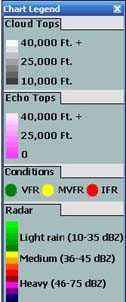
The graphic image, updated every morning, will show TFRs, radar,
cloud cover, winds aloft, and other data... all appearing on a
chart similar to what you'll find in Seattle Avionics' Voyager
FreeFlight software.
What's more, you can customize this image to display whatever
YOU want to show!
Traveling To Oshkosh?
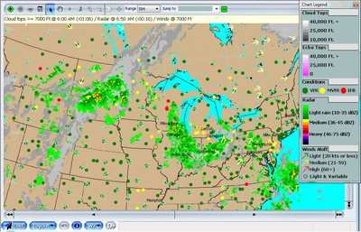
This morning's weather report and airspace update are shown
updated at 1203Z 07.26.07
 SYNOPSIS...COLD FRONT 70NW RAP-SFC
LOW 30SW FAR-50WNW INL. SURFACE TROUGH 30SW FAR-BFF-SFC LOW 40NE
GLD-40W LBL. 04Z COLD FRONT FROM SURFACE LOW 70NNE SAW-40NW DLL-SFC
LOW 40S FOD-SFC LOW GCK.
SYNOPSIS...COLD FRONT 70NW RAP-SFC
LOW 30SW FAR-50WNW INL. SURFACE TROUGH 30SW FAR-BFF-SFC LOW 40NE
GLD-40W LBL. 04Z COLD FRONT FROM SURFACE LOW 70NNE SAW-40NW DLL-SFC
LOW 40S FOD-SFC LOW GCK.
WI WESTERN 1/3...ABOVE GROUND LEVEL SCATTERED 3/8-4/8 COVERAGE
AT 4500 FT. UNTIL 13Z OCCASIONAL VIS 3SM MIST. 18Z SCATTERED LIGHT
THUNDERSTORM RAIN. CUMULONIMBUS TOP FL450. THUNDERSTORM IN LNS AND
POSS SEVERE. OUTLOOK...VFR THUNDERSTORM RAIN. EASTERN 2/3...CEILING
BROKEN 5/8-7/8 COVERAGE AT 5000 FT LAYERED FL180. ISOL LIGHT
THUNDERSTORM RAIN. CUMULONIMBUS TOP FL420. UNTIL 13Z OCCASIONAL 3SM
MIST. 17Z WIDELY SCATTERED LIGHT THUNDERSTORM RAIN. CUMULONIMBUS
TOP FL450. OUTLOOK...VFR THUNDERSTORM RAIN.
LM LOWER MI LH NORTHERN PORTIONS...SKY CLEAR. UNTIL 12Z
OCCASIONAL CEILING OVERCAST AT 1000 FT TOP 030. VIS 3SM MIST. 15Z
ABOVE GROUND LEVEL SCATTERED 3/8-4/8 COVERAGE AT 6000 FT.
OUTLOOK...VFR 02Z THUNDERSTORM RAIN NORTHERN LM/NORTHWESTERN LOWER
MI. SOUTHERN LM...CEILING BROKEN 5/8-7/8 COVERAGE AT 6000 FT
LAYERED FL300. ISOLATED LIGHT THUNDERSTORM RAIN. CUMULONIMBUS TOP
FL370. THUNDERSTORM IN LNS. 15Z CEILING BROKEN 5/8-7/8 COVERAGE AT
4000 FT. ISOL LIGHT THUNDERSTORM RAIN. THUNDERSTORM IN LNS.
CUMULONIMBUS TOP FL420. OUTLOOK...VFR THUNDERSTORM RAIN.
REMAINDER...SKY CLEAR. UNTIL 12Z OCCASIONAL CEILING OVERCAST AT
1000 FT TOP 030. VIS 3SM MIST. 15Z ABOVE GROUND LEVEL SCATTERED
3/8-4/8 COVERAGE AT 3500 FT. ISOLATED LIGHT THUNDERSTORM RAIN.
CUMULONIMBUS TOP FL390. OUTLOOK...VFR.
IL NORTHEASTERN...CEILING BROKEN 5/8-7/8 COVERAGE AT 6000 FT TOP
150. ISOL LIGHT THUNDERSTORM RAIN. CUMULONIMBUS TOP FL370. 16Z
CUMULONIMBUS TOP FL400. 19Z CUMULONIMBUS TOP FL450. OUTLOOK...VFR
UNTIL 00Z THUNDERSTORM RAIN. REMAINDER...ABOVE GROUND LEVEL
SCATTERED 3/8-4/8 COVERAGE AT 5000 FT SCATTERED 3/8-4/8
COVERAGE-BROKEN 5/8-7/8 COVERAGE AT 12000 FT. UNTIL 12Z VIS 5SM
MIST. OUTLOOK...VFR.
Pretty cool, eh? But wait... it gets even better. In addition to
displaying this information on the Aero-News website... Seattle
Avionics is also offering a special, FREE version of Voyager
FreeFlight for ANN readers to download for their personal use.

For an up-to-the-minute look at the weather, airspace, and
airport data for your flight, be sure to download your 100% FREE
version of Voyager FreeFlight Flight Planner, courtesy of
Aero-News. Use it for your flight to Oshkosh... and for your
flights to come!
FMI: Download Your ANN FreeFlight Flight Planner Here
 Airborne-Flight Training 05.09.24: ERAU at AIAA, LIFT Diamond Buy, Epic A&P

