NASA Crowd Sourcing Two New Weather And Environmental Satellite Apps | Aero-News Network
Aero-News Network
RSS icon RSS feed
podcast icon MP3 podcast
Subscribe Aero-News e-mail Newsletter Subscribe

Airborne Unlimited -- Most Recent Daily Episodes

Episode Date

Airborne-Monday

Airborne-Tuesday

Airborne-Wednesday Airborne-Thursday

Airborne-Friday

Airborne On YouTube

Airborne-Unlimited-05.13.24

Airborne-NextGen-05.07.24

Airborne-Unlimited-05.08.24 Airborne-FlightTraining-05.09.24

Airborne-Unlimited-05.10.24

Mon, Dec 29, 2014

NASA Crowd Sourcing Two New Weather And Environmental Satellite Apps

SatCam And WxSAT Available Free To All Users

National Oceanic and Atmospheric Administration (NOAA)’s academic partner, the Space Science and Engineering Center (SSEC) at the University of Wisconsin-Madison has developed two free mobile apps that bring the ability to see and capture satellite data to mobile users’ fingertips.  The apps received development support from NOAA and NASA.

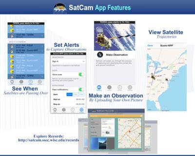
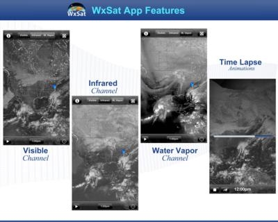
The SatCam app for iOS devices allows mobile users to capture observations of sky and ground conditions at the same time that an Earth observing satellite is overhead. The WxSat (short for Weather Satellite) app, for iOS and android, displays and animates full-resolution, real-time weather satellite data. WxSat leverages the SSEC Data Center holdings to provide global coverage for visible, infrared, and water vapor channels.

When users capture a SatCam observation and submit it to the SatCam server, it helps to check the quality of the cloud products that are created from satellite data. In return for the observation submission, SatCam sends users the satellite image that was captured at their location. The SatCam software supports NASA’s Terra and Aqua satellites as well as the NOAA/NASA Suomi-NPP satellite. SatCam images help SSEC to perfect the cloud mask products that are applied to data collected from the satellites. Cloud mask indicates whether a given view of the Earth is obstructed by clouds or aerosol and can be misinterpreted when cloud temperature is too similar to ground temperature.

"SatCam is a great example of a citizen science app that allows anyone with an iPhone to help improve the data products from instruments onboard three flagship Earth science missions,” said Steve Graham, a senior outreach specialist for Global Science and Technology, Inc. at NASA’s Goddard Space Flight Center, Greenbelt, Maryland. He has also been the outreach coordinator for the Aqua mission (formerly PM-1) since March 2000.

Geostationary and polar orbiting weather satellites, like Suomi-NPP, continuously capture observations of the earth. Data from these satellites are acquired by the SSEC Data Center which has one of the most extensive collections of real-time and archived weather satellite data in the world. WxSat blends those images into single hourly global composites for three different products (Visible, Infrared, and Water Vapor) and is updated every hour at 36 minutes past the hour.

The names of the different images in the WxSat app refer to the parts of the electromagnetic spectrum from which the satellite sensors are sampling. The three most widely used atmospheric channels are the visible, infrared, and water vapor. NOAA forecasters combine information from the three types of images to predict weather, monitor forest fires, ice flows, ocean currents, and long term climate patterns from a global perspective that only satellites can provide.

These SSEC apps are freely available to all interested users.

(Images provided by NASA)

FMI: www.ssec.wisc.edu/apps

Advertisement

More News

Airborne 05.10.24: Icon Auction, Drunk MedEvac Pilot, Bell ALFA

Also: SkyReach Parts Support, Piper Service Ctr, Airliner Near-Miss, Airshow London The Judge overseeing Icon's convoluted Chapter 11 process has approved $9 million in Chapter 11 >[...]

ANN's Daily Aero-Term (05.13.24): ILS PRM Approach

ILS PRM Approach An instrument landing system (ILS) approach conducted to parallel runways whose extended centerlines are separated by less than 4,300 feet and at least 3,000 feet >[...]

ANN's Daily Aero-Linx (05.13.24)

Aero Linx: FlyPups FlyPups transports dogs from desperate situations to fosters, no-kill shelters, and fur-ever homes. We deliver trained dogs to veterans for service and companion>[...]

Airborne-NextGen 05.07.24: AI-Piloted F-16, AgEagle, 1st 2 WorldView Sats

Also: Skydio Chief, Uncle Sam Sues, Dash 7 magniX, OR UAS Accelerator US Secretary of the Air Force Frank Kendall was given a turn around the patch in the 'X-62A Variable In-flight>[...]

Airborne 05.08.24: Denali Update, Dad-Daughter Gyro, Lake SAIB

Also: NBAA on FAA Reauth, DJI AG Drones, HI Insurance Bill Defeated, SPSA Airtankers The Beechcraft Denali continues moving forward towards certification, having received its FAA T>[...]

blog comments powered by Disqus


Advertisement

Advertisement

Podcasts

Advertisement

© 2007 - 2024 Web Development & Design by Pauli Systems, LC