Could Robots Become Human 'Eyes' In Hurricanes? | Aero-News Network
Aero-News Network
RSS icon RSS feed
podcast icon MP3 podcast
Subscribe Aero-News e-mail Newsletter Subscribe

Airborne Unlimited -- Most Recent Daily Episodes

Episode Date

Airborne-Monday

Airborne-Tuesday

Airborne-Wednesday Airborne-Thursday

Airborne-Friday

Airborne On YouTube

Airborne-Unlimited-05.13.24

Airborne-NextGen-05.07.24

Airborne-Unlimited-05.08.24 Airborne-FlightTraining-05.09.24

Airborne-Unlimited-05.10.24

Thu, Sep 14, 2006

Could Robots Become Human 'Eyes' In Hurricanes?

Tiny UAV Does Yeoman's Duty

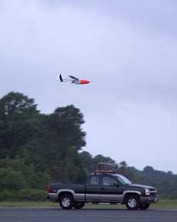
NASA and NOAA are testing what they call Aerosondes -- tiny unmanned aircraft that can be launched from a pick-up truck. They're designed to monitor temperature, humidity and wind velocity in hurricanes long before they get close to shore.

But these UAVs are designed to go where manned hurricane hunters can't -- just a few thousand feet above the ocean surface. That's in the harshest part of the storm.

These tiny aircraft carry all of the sophisticated instruments used in traditional hurricane observations, including GPS and a satellite communications system that relays all the information in real-time. Additionally, they utilize an infrared sensor used to estimate the underlying sea surface temperature.

According to NewScientist.com, each Aerosonde costs about $50,000. They can fly for 18 hours below 1000 ft carrying around 10 lbs of instruments and communication gear.

"The concept of the Aerosonde as a small, robust unmanned autonomous vehicle, or UAV, arose directly from our need for observations in dangerous areas such as the hurricane surface layer," said Greg Holland, president of Aerosonde North America and one of the Aerosonde originators.

Up until now, hurricane hunters have used dropsondes. But they go straight down into the water and provide spotty coverage of low-level hurricane conditions at best.

"It's been a long road to get to this point, but it was well worth the wait," said Joe Cione, NOAA hurricane researcher at the Atlantic Oceanographic and Meteorology Laboratory (AOML) in Miami and the lead scientist on this project. "If we want to improve future forecasts of hurricane intensity change we will need to get continuous low-level observations near the air-sea interface on a regular basis."

The environment near the surface is critically important to researchers -- it's where the sea's energy, in the form of heat, is transferred to the storm. It's also where the most powerful winds occur. Both of these data points will give scientists much-needed real-time information to help them understand why some of these storms intensify so quickly.

FMI: www.noaa.gov, www.nasa.gov

Advertisement

More News

Bolen Gives Congress a Rare Thumbs-Up

Aviation Governance Secured...At Least For a While The National Business Aviation Association similarly applauded the passage of the FAA's recent reauthorization, contentedly recou>[...]

The SportPlane Resource Guide RETURNS!!!!

Emphasis On Growing The Future of Aviation Through Concentration on 'AFFORDABLE FLYERS' It's been a number of years since the Latest Edition of Jim Campbell's HUGE SportPlane Resou>[...]

Buying Sprees Continue: Textron eAviation Takes On Amazilia Aerospace

Amazilia Aerospace GmbH, Develops Digital Flight Control, Flight Guidance And Vehicle Management Systems Textron eAviation has acquired substantially all the assets of Amazilia Aer>[...]

Hawker 4000 Bizjets Gain Nav System, Data Link STC

Honeywell's Primus Brings New Tools and Niceties for Hawker Operators Hawker 4000 business jet operators have a new installation on the table, now that the FAA has granted an STC f>[...]

Echodyne Gets BVLOS Waiver for AiRanger Aircraft

Company Celebrates Niche-but-Important Advancement in Industry Standards Echodyne has announced full integration of its proprietary 'EchoFlight' radar into the e American Aerospace>[...]

blog comments powered by Disqus


Advertisement

Advertisement

Podcasts

Advertisement

© 2007 - 2024 Web Development & Design by Pauli Systems, LC