Jeppesen Unveils New Logo, Product At AirVenture 2008 | Aero-News Network
Aero-News Network
RSS icon RSS feed
podcast icon MP3 podcast
Subscribe Aero-News e-mail Newsletter Subscribe

Airborne Unlimited -- Most Recent Daily Episodes

Episode Date

Airborne-Monday

Airborne-Tuesday

Airborne-Wednesday Airborne-Thursday

Airborne-Friday

Airborne On YouTube

Airborne-Unlimited-05.13.24

Airborne-NextGen-05.07.24

Airborne-Unlimited-05.08.24 Airborne-FlightTraining-05.09.24

Airborne-Unlimited-05.10.24

Tue, Jul 29, 2008

Jeppesen Unveils New Logo, Product At AirVenture 2008

New VFR+GPS Nav Chart Billed As "Perfect VFR Chart"

Jeppeson unveiled its new corporate logo reflecting the evolution of its products and services, as well as its expansion into all transportation markets. Known for its aeronautical navigational products, now they offer an array of solutions for land and sea operations as well.

The logo is known as The Edge. The transition from an airplane silhouette into a series of stacked shapes represents Jeppesen's forward movement. Mark Van Tine, Jeppesen president and CEO, says, "I believe our new logo communicates the image we want the people to embrace when they think of Jeppesen... for our long-standing aviation customers, the message is that we are much more than 'just that old chart company.'"

In the coming months, the logo will be rolled out across its products and in a new website, currently under development.

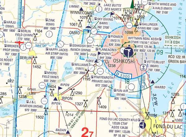
Jeppesen also announced the release of the new VFR+GPS charts for navigation in North America. Initially developed in Europe many years ago, it is a clean-sheet design. Incorporating color and contrast to make a VFR chart easier to read and interpret, it also adds GPS elements, such as all airport identifiers and GPS waypoints.

The depiction of Class B, C, D and E airspace is much more easily understood, with altitude limits clearly shown. Data from NAVTEQ provides the latest information on roads, cities, and points of interest easily identified from the air. Terrain data from the Space Shuttle radar missions provide a realistic depiction of the earth below. State-of-the-art charting tools combine the data for a clean, intuitive look. JeppGuide airport diagrams are on the back of each chart.

Christopher Dean, product manager for business and general aviation at Jeppesen, briefed the media on the new charts. "The new charts were designed by pilots for pilots," says Dean. "It's the perfect VFR chart."

The new coverage areas will initially include enroute and area charts from Miami to Atlanta. Launch kits will be sent to area FBOs next week. Expansion to other areas across the lower 48 states of the US will be completed by late 2009. The latest enroute chart offered covers Wisconsin and Illinois, which will be featured as a Special Oshkosh Commemorative Chart during AirVenture at the Jeppesen booth.

The initial cost of the charts will be $9.95 for the enroute charts and $5.95 for the area charts. A digital rollout will occur once all the North American charts are completed.

FMI: www.jeppesen.com

Advertisement

More News

Sierra Space Repositions Dream Chaser for First Mission

With Testing Soon Complete, Launch Preparations Begin in Earnest Sierra Space's Dream Chaser has been put through the wringer at NASA's Glenn Armstrong Test Facility in Ohio, but w>[...]

ANN's Daily Aero-Term (05.10.24): Takeoff Roll

Takeoff Roll The process whereby an aircraft is aligned with the runway centerline and the aircraft is moving with the intent to take off. For helicopters, this pertains to the act>[...]

Aero-News: Quote of the Day (05.10.24)

“We’re proud of the hard work that went into receiving this validation, and it will be a welcome relief to our customers in the European Union. We couldn’t be mor>[...]

Aero-News: Quote of the Day (05.11.24)

"Aircraft Spruce is pleased to announce the acquisition of the parts distribution operations of Wag-Aero. Wag-Aero was founded in the 1960’s by Dick and Bobbie Wagner in the >[...]

ANN's Daily Aero-Term (05.11.24): IDENT Feature

IDENT Feature The special feature in the Air Traffic Control Radar Beacon System (ATCRBS) equipment. It is used to immediately distinguish one displayed beacon target from other be>[...]

blog comments powered by Disqus


Advertisement

Advertisement

Podcasts

Advertisement

© 2007 - 2024 Web Development & Design by Pauli Systems, LC