Offers Comprehensive Airport Monitoring Feature Set For Aircraft
Garmin has introduced Terminal Safety Solutions, a unique set of technologies that provide a better state of situational awareness to pilots throughout the airport terminal environment, including SurfaceWatch, TerminalTraffic and SafeTaxi.
These safety enhancing tools provide pilots with a clear understanding of their location within the terminal environment relative to traffic on the ground and in the air, while also proactively providing notifications of potential runway incursions or surface incidents.
“Garmin is known for providing unsurpassed situational awareness tools in the cockpit and we’re excited to present this family of safety enhancing features to our customers to bring optimal situational awareness in the terminal airport environment,” said Carl Wolf, vice president of aviation marketing and sales. “These tools are the culmination of years of hard work and thousands of flight test hours performed by passionate pilots and engineers striving to improve the picture in and around the airport and they have done so like no one else in the industry.”
SurfaceWatch provides visual and aural tools to help prevent pilots from taking off and landing on a taxiway, on a runway that is too short or on the wrong runway. For example, in the event the aircraft is aligned to take-off on a runway that is too short, the flight crew receives a brief “runway too short” aural annunciation and visual message on the PFD, based on the Takeoff and Landing Distance (TOLD) performance data entered during preflight. While the aircraft is on take-off roll, runway distance remaining information is also displayed on the PFD. In the absence of TOLD calculations, pilots can manually enter minimum runway length information and also receive alerts in the event the aircraft is on the wrong runway. Additionally, audible runway distance remaining annunciations are optionally available, which provides callouts beginning at 5,000 feet through 500 feet.
SurfaceWatch is offered through Garmin’s Original Equipment Manufacturer (OEM) network and is available as an option with select G2000, G3000 and G5000 Integrated Flight Decks.
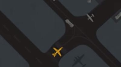
TerminalTraffic provides pilots with the most comprehensive picture of ADS-B-equipped aircraft and ground vehicles in the airport environment. ADS-B-equipped ground vehicles and taxiing aircraft are easily distinguished from aircraft in-flight, which are displayed using distinct colors and symbols. Audible traffic alerts further enhance situational awareness to ensure traffic conflicts are not overlooked throughout critical operations such as takeoff and landing. All of this information is presented to the pilot on a simple, easy to understand SafeTaxi diagram with reference to runways, taxiways, hangar locations and more.
Pilots can receive the benefits of safety enhancing TerminalTraffic by pairing the GDL 88/GDL 84 ADS-B datalink or GDL 39/GDL 39R/GDL 39 3D portable ADS-B receiver with compatible Garmin displays.
Recognizing the unique operations performed by helicopters within the airport environment, TerminalTraffic has been optimized to minimize nuisance alerts while maintaining awareness of potential traffic conflicts. When operating in the airport environment, alerts from fixed-wing aircraft are minimized and abbreviated while performing unique helicopter maneuvers such as hovering. These tailored alerts are accompanied by an abbreviated aural “traffic” alert when operating below 400 feet and 40 knots to minimize audio traffic in the cockpit during critical times.
The GDL 88H is a variant of the GDL 88, which is designed specifically for helicopter applications and displays TerminalTraffic tailored to these operators on compatible Garmin displays.
Pilots can navigate airports with ease using geo-referenced Garmin SafeTaxi airport diagrams, which display runways, taxiways, FBOs, and hangars, relative to the aircraft’s location on the field. Hot Spots identifying confusing or complex taxiway and/or runway intersections, as well as hold short lines are overlaid on SafeTaxi diagrams to provide pilots with added situational awareness. SafeTaxi is seamlessly integrated with existing basemap data so airport information automatically appears at the appropriate map range setting and increases in detail when the map is scaled accordingly.
SafeTaxi airport diagrams are available for over 2,000 airports in the U.S., Canada and Europe and the database continues to grow. Geo-referenced SafeTaxi diagrams can optionally be displayed on a wide variety of Garmin Integrated Flight Decks, certified avionics and portables.
(Source: Garmin news release. Images from Garmin video)
 ANN's Daily Aero-Term (04.26.24): DETRESFA (Distress Phrase)

