Latest WingX Pro Release Includes New Helicopter Charts | Aero-News Network
Aero-News Network
RSS icon RSS feed
podcast icon MP3 podcast
Subscribe Aero-News e-mail Newsletter Subscribe

Airborne Unlimited -- Most Recent Daily Episodes

Episode Date

Airborne-Monday

Airborne-Tuesday

Airborne-Wednesday Airborne-Thursday

Airborne-Friday

Airborne On YouTube

Airborne-Unlimited-05.13.24

Airborne-NextGen-05.07.24

Airborne-Unlimited-05.08.24 Airborne-FlightTraining-05.09.24

Airborne-Unlimited-05.10.24

Tue, Dec 22, 2015

Latest WingX Pro Release Includes New Helicopter Charts

Routes And Gulf Coast Charts Can Now Be Laid Over Sectionals

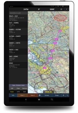
The latest version of WingX Pro7 (8.6.1) includes some new features specifically targeted at helicopter operators.

According to the company, Helicopter Routes and Helicopter Gulf Coast Charts can seamlessly be overlaid on sectionals - Helicopter Route Charts provide valuable information to helicopter and fixed-wing pilots flying in high-density areas such as near JFK.

In addition, Grand Canyon Charts for General Aviation provide more precise information for GA pilots flying in and around the Grand Canyon. Grand Canyon Charts for Tour Operators allow tour operators more heads-up time for added safety.

Terrain Underlay, another WingX Pro7 innovation, allows pilots to view bodies of water on their IFR enroute charts (WingX Pro7 for Android already has Terrain Underlay).

The company has also announced support for several less-expensive ADS-B receivers, including Dual XGPS190, Stratux, and Bad Elf.

The company says that in this latest release, NORAD Procedures are now included in WingX Pro7 right on the Moving Map screen.

The document includes:

  • Flight Planning and Enroute TFR Information
  • Intercept Procedures
  • Your Actions when Intercepted
  • Post Intercept Procedures
  • Day Intercept Signals
  • Night Intercept Signals

Some pilots have asked for the option to turn Terminal Aeronautical Charts (TACs) on/off. Version 8.6.1 adds that option.

And the company's "CFI Free!" program is now available for WingX Pro7 for iOS, WingX Pro7 for Android, and WingX Pro7 for Fire.

Hilton software says that two minor issues have been discovered in Version 8.6.1 - and an update has been released which is now awaiting Apple's approval. Those issues are:

  • Selecting None as a map background displays black background instead of gray
  • Downloading All USA Sectional does not include Alaska.  Workaround: If you require Alaska, download Alaska instead of “All USA”

(Images from file)

FMI: www.hiltonsoftware.com

Advertisement

More News

Bolen Gives Congress a Rare Thumbs-Up

Aviation Governance Secured...At Least For a While The National Business Aviation Association similarly applauded the passage of the FAA's recent reauthorization, contentedly recou>[...]

The SportPlane Resource Guide RETURNS!!!!

Emphasis On Growing The Future of Aviation Through Concentration on 'AFFORDABLE FLYERS' It's been a number of years since the Latest Edition of Jim Campbell's HUGE SportPlane Resou>[...]

Buying Sprees Continue: Textron eAviation Takes On Amazilia Aerospace

Amazilia Aerospace GmbH, Develops Digital Flight Control, Flight Guidance And Vehicle Management Systems Textron eAviation has acquired substantially all the assets of Amazilia Aer>[...]

Hawker 4000 Bizjets Gain Nav System, Data Link STC

Honeywell's Primus Brings New Tools and Niceties for Hawker Operators Hawker 4000 business jet operators have a new installation on the table, now that the FAA has granted an STC f>[...]

Echodyne Gets BVLOS Waiver for AiRanger Aircraft

Company Celebrates Niche-but-Important Advancement in Industry Standards Echodyne has announced full integration of its proprietary 'EchoFlight' radar into the e American Aerospace>[...]

blog comments powered by Disqus


Advertisement

Advertisement

Podcasts

Advertisement

© 2007 - 2024 Web Development & Design by Pauli Systems, LC