Airmate EFB Adds Synthetic Vision | Aero-News Network
Aero-News Network
RSS icon RSS feed
podcast icon MP3 podcast
Subscribe Aero-News e-mail Newsletter Subscribe

Airborne Unlimited -- Most Recent Daily Episodes

Episode Date

Airborne-Monday

Airborne-Tuesday

Airborne-Wednesday Airborne-Thursday

Airborne-Friday

Airborne On YouTube

Airborne-Unlimited-05.06.24

Airborne-NextGen-04.30.24

Airborne-Unlimited-05.01.24 Airborne-AffordableFlyers--05.02.24

Airborne-Unlimited-05.03.24

Wed, Jun 15, 2022

Airmate EFB Adds Synthetic Vision

Popular Flight Planning & Weather App Ups Capability

Airmate EFB, the free, flight-planning and weather app, now offers synthetic vision. The feature is provided free of charge to Airmate users. Formerly, synthetic vision capability required a premium subscription plan.

The Airmate app is compatible with iPhone, iPad, and Android phone or tablets. User inputs and data are synced with Airmate Web Flight Planning, thereby permitting users to flight-plan at home and fly with their devices. Data can also be shared among devices. 

Airmate displays an EFIS/AHRS view, showing all flight parameters—to include the new, synthetic vision feature, which bases its depictions on a worldwide terrain database. The system can be used with either computer flight simulators or actual aircraft. In the latter instance, AHRS data are obtained from iOS accelerometers, onboard avionics, or an external ADS-B receiver. By providing the synthetic vision feature, Airmate seeks to increase flight safety by augmenting pilots’ situational awareness.

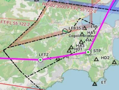
The app embeds worldwide ICAO VFR charts and official IFR High and Low enroute charts (provided by national AIP authorities). The charts, which may be downloaded free of charge, are geo-referenced, and can be overlaid on top of the Airmate moving map display.

Airmate users may also view and utilize VFR and IFR airport approach plates and SIDs / STARs procedures in more than 200 countries. 

The aforementioned navigational charts and approach aids derive of an AIRAC database sourced from FAA, Eurocontrol and numerous national authorities. Airmate supplements the database with information pertaining to peripheral landmarks and facilities such as unlicensed, or ultralight airfields. The database is updated—free of charge to Airmate users—at every AIRAC cycle.

In addition to flight-planning and aeronautical navigation data, Airmate grants users access to meteorological utilities such as: NOAA/FAA METAR, TAF, SIGMET, satellite charts, and radar/rainfall maps. 

FMI: www.airmate.aero

Advertisement

More News

ANN's Daily Aero-Linx (05.04.24)

Aero Linx: JAARS Nearly 1.5 billion people, using more than 5,500 languages, do not have a full Bible in their first language. Many of these people live in the most remote parts of>[...]

NTSB Final Report: Quest Aircraft Co Inc Kodiak 100

'Airplane Bounced Twice On The Grass Runway, Resulting In The Nose Wheel Separating From The Airplane...' Analysis: The pilot reported, “upon touchdown, the plane jumped back>[...]

Aero-News: Quote of the Day (05.04.24)

"Burt is best known to the public for his historic designs of SpaceShipOne, Voyager, and GlobalFlyer, but for EAA members and aviation aficionados, his unique concepts began more t>[...]

Aero-News: Quote of the Day (05.05.24)

"Polaris Dawn, the first of the program’s three human spaceflight missions, is targeted to launch to orbit no earlier than summer 2024. During the five-day mission, the crew >[...]

Read/Watch/Listen... ANN Does It All

There Are SO Many Ways To Get YOUR Aero-News! It’s been a while since we have reminded everyone about all the ways we offer your daily dose of aviation news on-the-go...so he>[...]

blog comments powered by Disqus


Advertisement

Advertisement

Podcasts

Advertisement

© 2007 - 2024 Web Development & Design by Pauli Systems, LC