Fri, Sep 07, 2018
Copernicus Satellite Is Expected To Be Launched In 2020
The integration of Sentinel-6A, the first of two satellites to continue measuring sea levels from 2020, has reached a new milestone and its critical phase: the propulsion module has been “mated” with the main structure of the satellite at Airbus.
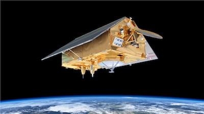
In a complex operation, the Airbus satellite specialists hoisted the approximately 16-foot high satellite platform with pinpoint precision over the drive module, which had already been positioned. The two components were then fixed in place and assembled. Before this could happen, the propulsion module, which includes the engines, control devices and a 63-gallon tank with an innovative fuel management system, had to undergo technical acceptance, since this subsystem can no longer be accessed once it has been integrated. The propulsion module now needs to be ‘hooked up’, which will then be followed by the system tests.
Two Sentinel-6 satellites for the European Copernicus Programme for environment and security, headed by the European Commission and ESA, are currently being developed under Airbus’ industrial leadership, each weighing roughly 1.5 tonnes. From November 2020, Sentinel-6A will be the first to continue collecting satellite-based measurements of the oceans’ surfaces, a task that began in 1992. Sentinel-6B is then expected to follow in 2025.
Sentinel-6 is a mission to carry out high-precision measurements of ocean surface topography. The satellite will measure its distance to the ocean surface with an accuracy of a few centimetres and, over a mission lasting up to seven years, use this data to map it, repeating the cycle every 10 days. It will document changes in sea-surface height, record and analyse variations in sea levels and observe ocean currents. Exact observations of changes in sea-surface height provide insights into global sea levels, the speed and direction of ocean currents, and ocean heat storage. The measurements made are vital for modelling the oceans and predicting possible rises in sea levels.
(Image provided with Airbus news release)
More News
Airport Rotating Beacon A visual NAVAID operated at many airports. At civil airports, alternating white and green flashes indicate the location of the airport. At military airports>[...]
Aero Linx: Fly for the Culture Fly For the Culture, Inc. is a 501(c)(3) non-profit organization that serves young people interested in pursuing professions in the aviation industry>[...]
Klyde Is Having Some Issues Comprehending The Fed's Priorities FMI: www.klydemorris.com>[...]
Also: Viasat-uAvionix, UL94 Fuel Investigation, AF Materiel Command, NTSB Safety Alert Norges Luftsportforbund chose Aura Aero's little 2-seater in electric trim for their next gli>[...]
Also: EP Systems' Battery, Boeing SAF, Repeat TBM 960 Order, Japan Coast Guard H225 Buy Despite nearly 100 complaints totaling millions of dollars of potential fraud, combined with>[...]
 ANN's Daily Aero-Term (04.25.24): Airport Rotating Beacon

