Wed, Sep 20, 2006
Will Allow Pilots To Use GPS For Primary Nav
Rockwell Collins told ANN this week the company has launched its
Wide Area Augmentation System (WAAS) capable GPS-4000S. The new
capability will be available in early 2007 -- and will give pilots
the ability to use GPS as a primary means of navigation.
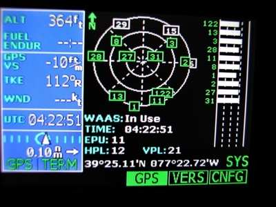
The GPS-4000S sensor and associated WAAS antenna will allow
operators to utilize the GPS system, without reliance on other
navigation equipment for en route operations and approach
procedures authorized for WAAS, such as RNAV (GPS) charts. A WAAS
receiver also streamlines preflight preparation by removing the
requirement to run a computer-based prediction of Receiver
Autonomous Integrity Monitoring (RAIM) availability along the
intended routes for US area navigation (RNAV) routes, Standard
Instrument Departures (SIDs), and Standard Terminal Arrivals
(STARs).
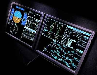
"Just like the GPS-4000A, the GPS-4000S is fully integrated with
the Flight Management Systems (FMS) in Rockwell Collins Pro Line 4
and Pro Line 21 systems to provide simple and intuitive
operation," said Denny Helgeson, vice president and general
manager of Business and Regional Systems for Rockwell Collins.
Operators with Rockwell Collins' Flight Management Systems (FMS)
who install a GPS-4000S will also be positioned to take advantage
of localizer performance vertical guidance (LPV ) approach
capability, upon availability of an FMS upgrade option which is
scheduled for initial certification in late 2007.
The first customer for this capability is the Federal Aviation
Administration (FAA), which signed a contract with Rockwell Collins
last November to add Wide Area Augmentation System functionality
with localizer performance with vertical guidance (WAAS LPV) to the
FAA's flight inspection aircraft.
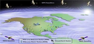
WAAS improves the availability and integrity of GPS navigation
by providing horizontal and vertical navigation for precision
approach operations for all users at all locations. Additionally,
WAAS provides service for all classes of aircraft in all flight
operations, including en route navigation, airport departures, and
airport arrivals. This includes precision landing approaches with
minimums as low as 200 feet at locations throughout the National
Airspace System.
More News
Airport Rotating Beacon A visual NAVAID operated at many airports. At civil airports, alternating white and green flashes indicate the location of the airport. At military airports>[...]
Aero Linx: Fly for the Culture Fly For the Culture, Inc. is a 501(c)(3) non-profit organization that serves young people interested in pursuing professions in the aviation industry>[...]
Klyde Is Having Some Issues Comprehending The Fed's Priorities FMI: www.klydemorris.com>[...]
Also: Viasat-uAvionix, UL94 Fuel Investigation, AF Materiel Command, NTSB Safety Alert Norges Luftsportforbund chose Aura Aero's little 2-seater in electric trim for their next gli>[...]
Also: EP Systems' Battery, Boeing SAF, Repeat TBM 960 Order, Japan Coast Guard H225 Buy Despite nearly 100 complaints totaling millions of dollars of potential fraud, combined with>[...]
 ANN's Daily Aero-Term (04.25.24): Airport Rotating Beacon

