CO TFR: 06.20.08 - 06.22.08 | Aero-News Network
Aero-News Network
RSS icon RSS feed
podcast icon MP3 podcast
Subscribe Aero-News e-mail Newsletter Subscribe

Airborne Unlimited -- Most Recent Daily Episodes

Episode Date

Airborne-Monday

Airborne-Tuesday

Airborne-Wednesday Airborne-Thursday

Airborne-Friday

Airborne On YouTube

Airborne-Unlimited-09.15.25

AirborneNextGen-
09.09.25

Airborne-Unlimited-09.10.25

Airborne-AffordableFlyers-09.11.25

AirborneUnlimited-09.12.25

Wed, Jun 18, 2008

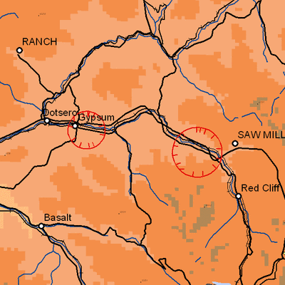
CO TFR: 06.20.08 - 06.22.08

NOTAM Number: FDC 8/2864
Issue Date: June 17, 2008 at 1410 UTC
Location: Avon, Colorado
Beginning Date and Time: June 20, 2008 at 0125 UTC
Ending Date and Time: June 22, 2008 at 1915 UTC
Reason for NOTAM: Temporary flight restrictions for VIP (Very Important Person) Movement
Type: VIP
Replaced NOTAM(s): N/A

Affected Area(s)

Area A
Airspace Definition:
 Center: On the SNOW VOR/DME (SXW) 069 degree radial at 3.5 nautical miles. (Latitude: 39º38'18"N, Longitude: 106º55'00"W)
 Radius: 3 nautical miles
 Altitude: From the surface up to but not including 3000 feet AGL
Effective Date(s):
 From June 20, 2008 at 0125 UTC (June 19, 2008 at 1925 MDT)
 To June 20, 2008 at 0215 UTC (June 19, 2008 at 2015 MDT)

Area B
Airspace Definition:
 Center: On the RED TABLE VOR/DME (DBL) 046 degree radial at 20 nautical miles. (Latitude: 39º36'58"N, Longitude: 106º31'41"W)
 Radius: 4 nautical miles
 Altitude: From the surface up to but not including 3000 feet AGL
Effective Date(s):
 From June 20, 2008 at 0210 UTC (June 19, 2008 at 2010 MDT)
 To June 22, 2008 at 1830 UTC (June 22, 2008 at 1230 MDT)

Area C
Airspace Definition:
 Center: On the SNOW VOR/DME (SXW) 069 degree radial at 3.5 nautical miles. (Latitude: 39º38'18"N, Longitude: 106º55'00"W)
 Radius: 3 nautical miles
 Altitude: From the surface up to but not including 3000 feet AGL
Effective Date(s):
 From June 22, 2008 at 1825 UTC (June 22, 2008 at 1225 MDT)
 To June 22, 2008 at 1915 UTC (June 22, 2008 at 1315 MDT)

Operating Restrictions and Requirements

No pilots may operate an aircraft in the areas covered by this NOTAM (except as described).

Unless otherwise authorized by ATC.

Other Information:

ARTCC: ZDV - Denver Center
Authority: Title 14 CFR section 91.141

FMI: www.tfr.faa.gov, Depicted TFR data may not be a complete listing. Pilots should not use the information on this website for flight planning purposes. For the latest information, call your local Flight Service Station at 1-800-WX-BRIEF.

Advertisement

More News

NTSB Final Report: Evektor-Aerotechnik A S Harmony LSA

Improper Installation Of The Fuel Line That Connected The Fuel Pump To The Four-Way Distributor Analysis: The airplane was on the final leg of a flight to reposition it to its home>[...]

ANN's Daily Aero-Term (09.15.25): Decision Altitude (DA)

Decision Altitude (DA) A specified altitude (mean sea level (MSL)) on an instrument approach procedure (ILS, GLS, vertically guided RNAV) at which the pilot must decide whether to >[...]

Aero-News: Quote of the Day (09.15.25)

“With the arrival of the second B-21 Raider, our flight test campaign gains substantial momentum. We can now expedite critical evaluations of mission systems and weapons capa>[...]

Airborne 09.12.25: Bristell Cert, Jetson ONE Delivery, GAMA Sales Report

Also: Potential Mars Biosignature, Boeing August Deliveries, JetBlue Retires Final E190, Av Safety Awareness Czech plane maker Bristell was awarded its first FAA Type Certification>[...]

Airborne 09.10.25: 1000 Hr B29 Pilot, Airplane Pile-Up, Haitian Restrictions

Also: Commercial A/C Certification, GMR Adds More Bell 429s, Helo Denial, John “Lucky” Luckadoo Flies West CAF’s Col. Mark Novak has accumulated more than 1,000 f>[...]

blog comments powered by Disqus


Advertisement

Advertisement

Podcasts

Advertisement

© 2007 - 2025 Web Development & Design by Pauli Systems, LC