LM Indago 3 UAS Supports Long-Range Secure ISR With Software By Trellisware | Aero-News Network
Aero-News Network
RSS icon RSS feed
podcast icon MP3 podcast
Subscribe Aero-News e-mail Newsletter Subscribe

Airborne Unlimited -- Most Recent Daily Episodes

Episode Date

Airborne-Monday

Airborne-Tuesday

Airborne-Wednesday Airborne-Thursday

Airborne-Friday

Airborne On YouTube

Airborne-Unlimited-05.19.25

Airborne-NextGen-05.20.25

AirborneUnlimited-05.21.25

Airborne-AffordableFlyers-05.22.25

AirborneUnlimited-05.23.25

Thu, May 11, 2017

LM Indago 3 UAS Supports Long-Range Secure ISR With Software By Trellisware

Enables Operators To Securely Complete ISR Missions

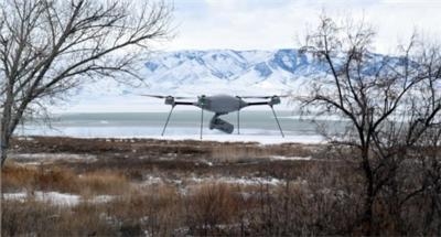
The newest version of Lockheed Martin’s Indago quadrotor unmanned aerial system (UAS), Indago 3, now enables military operators to securely complete sensitive intelligence, surveillance and reconnaissance (ISR) missions with the addition of TrellisWare Technologies MANET software products.

“Indago 3 gives our customers a quiet, durable, long-range system to complete sensitive operations with a small UAS,” said Rich Bonnett, Indago program manager, Lockheed Martin unmanned systems. “Our military customers tell us that Indago 3 gives them superior security, reliability and ruggedness compared to other UAS. We continue to enhance the Indago system based on customer feedback.”

Indago 3’s minimal radio frequency footprint is achieved by using the TW-600 Ocelot module by TrellisWare.

“The Ocelot module, equipped with TrellisWare’s robust TSM networking, is built specifically for integration into UAS,” said Matt Fallows, Director of Applications & Systems at TrellisWare. “We are pleased to partner with Lockheed Martin to help enhance Indago 3’s airborne networking in challenging environments with reliable and long range connections.”

Compared to previous versions of Indago, the enhanced Indago 3 system offers:

  • Military-grade encrypted and secure data link;
  • Secure, mesh capable video dissemination across multi-node networks and
  • Extended range radio for long distance operation at low-flight altitudes.

Along with a low acoustic and visual signature during startup and flight, Indago 3 is also available in haze grey, which minimizes visual detection during missions. Depending on payloads, Indago 3 has a flight time of up to 50 minutes, a range of 10 kilometers and a cruise speed of 25 mph and can operate at temperatures as low as 30-degrees below zero, and as high as 120 degrees.

The collapsible Indago quadrotor UAS weighs less than 5 lbs. and folds into a man-packable unit that requires no tools for assembly. Indago can be unfolded in 60 seconds, and airborne in just 2.5 minutes. Indago 3 offers additional durability for operation in harsh environments and weather conditions.

Lockheed Martin Procerus Technologies is the original equipment manufacturer of the Indago system and other unmanned aerial products including flight control systems, rotorcrafts, and fixed wing systems.

(Image provided with Lockheed Martin news release)

FMI: www.lockheedmartin.com

Advertisement

More News

Oshkosh Memories: An Aero-News Stringer Perspective

From 2021: The Inside Skinny On What Being An ANN Oshkosh Stringer Is All About By ANN Senior Stringer Extraordinare, Gene Yarbrough The annual gathering at Oshkosh is a right of p>[...]

NTSB Prelim: Piper PA32RT

Video Showed That During The Takeoff, The Nose Baggage Door Was Open On May 10, 2025, about 0935 eastern daylight time, a Piper PA-32RT-300, N30689, was destroyed when it was invol>[...]

ANN FAQ: Follow Us On Instagram!

Get The Latest in Aviation News NOW on Instagram Are you on Instagram yet? It's been around for a few years, quietly picking up traction mostly thanks to everybody's new obsession >[...]

Aero-News: Quote of the Day (05.28.25)

"I think what is key, we have offered a bonus to air traffic controllers who are eligible to retire. We are going to pay them a 20% bonus on their salary to stay longer. Don't reti>[...]

ANN's Daily Aero-Term (05.28.25): Pilot Briefing

Aero Linx: Pilot Briefing The gathering, translation, interpretation, and summarization of weather and aeronautical information into a form usable by the pilot or flight supervisor>[...]

blog comments powered by Disqus


Advertisement

Advertisement

Podcasts

Advertisement

© 2007 - 2025 Web Development & Design by Pauli Systems, LC