Mon, Apr 22, 2019
SBG Systems Will Have The Device At AUVSI Xponential In Chicago
SBG Systems will present for the first time at AUVSI’s Xponential show in Chicago the Quanta UAV Series, a new line of Inertial Navigation Systems (INS) dedicated to UAV-based Surveying Integrators.
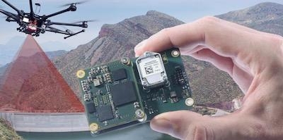
Because SBG Systems wants UAV surveyors to save autonomy for additional survey lines, the company has designed a small, lightweight, and low-power inertial navigation system offered on two levels of accuracy. Quanta UAV and Quanta UAV Extra have been developed for compact LiDAR to high end BVLOS mapping solutions. They provide precise orientation and centimeter level position data delivered both in real-time and post-processing. This direct geo-referencing solution eliminates the need of ground control points and greatly reduces the need of overlapping.
Qinertia, SBG’s post-processing software completes the Quanta UAV offer. It gives access to offline RTK corrections from more than 7,000 base stations located in 164 countries. Trajectory and orientation are greatly improved by processing inertial data and raw GNSS observables in forward and backward directions. This advanced software also computes your base station position to quickly get your project to-the-centimeter accuracy. Qinertia is one year free when buying a Quanta UAV sensor.
Quanta UAV is the result of SBG’s expertise in both miniaturized technology for drone navigation and high end sensors for mobile mapping. Designed as a geo-referencing solution, it can also be used as a high-end navigation solution to feed the UAV autopilot. Quanta UAV benefits from a tight integration with in-house IMUs, advanced calibration techniques and algorithms which ensure a consistent behavior in all weather conditions, as well as a robust position even if the UAV gets close to buildings, electrical lines, or trees.
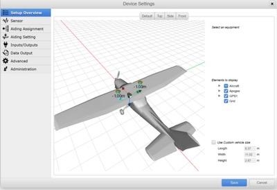
It is in SBG Systems’ DNA to make your life easier and give you full satisfaction. Quanta UAV embeds a web interface for an easy configuration with a 3D view showing all parameters. The calibration tool automatically aligns the lever arm between the two antennas and the sensor, and re-estimates it in flight for more precision. Asking for More simplicity? The SBG Support Team is there to help the user for no extra cost, and Quanta UAV benefits from a two-year warranty and unlimited firmware updates.
(Images provided with SBG Systems news release)
More News
Pilot Applied Full Aft Stick And Nose-Up Trim, But The Airplane Remained On The Runway Analysis: The pilot reported that a preflight inspection and flight control checks revealed n>[...]
A Few Questions AND Answers To Help You Get MORE Out of ANN! 1) I forgot my password. How do I find it? 1) Easy... click here and give us your e-mail address--we'll send it to you >[...]
From 2022 (YouTube Edition): Before They’re All Gone... Humankind has been messing about in airplanes for almost 120-years. In that time, thousands of aircraft representing i>[...]
Advanced Air Mobility (AAM) A transportation system that transports people and property by air between two points in the NAS using aircraft with advanced technologies, including el>[...]
Aero Linx: MQ-1B Predator The MQ-1B Predator is an armed, multi-mission, medium-altitude, long-endurance remotely piloted aircraft that is employed primarily as an intelligence-col>[...]
 NTSB Final Report: Douglas A-4K

