Classic Aero-TV: WSI’s Pilotbrief – Staying Ahead of the Weather | Aero-News Network
Aero-News Network
RSS icon RSS feed
podcast icon MP3 podcast
Subscribe Aero-News e-mail Newsletter Subscribe

Airborne Unlimited -- Most Recent Daily Episodes

Episode Date

Airborne-Monday

Airborne-Tuesday

Airborne-Wednesday Airborne-Thursday

Airborne-Friday

Airborne On YouTube

Airborne-Unlimited-06.23.25

Airborne-NextGen-06.24.25

AirborneUnlimited-06.25.25

Airborne-AffordableFlyers-06.26.25

AirborneUnlimited-06.27.25

Wed, Apr 07, 2010

Classic Aero-TV: WSI’s Pilotbrief – Staying Ahead of the Weather

WSI Illustrates One Of The Ultimate Services for Enhanced Weather Data

E-I-C Note: As ANN prepares for its first major LIVE Aero-TV programming, we have to admit that we've been flogging the video geeks to within an inch of their lives to get ready... Still, before we really put the pressure on, we've decided to give them a SLIGHT break and will be offering classic episodes of Aero-TV, all with an Avionics Theme, in order to prepare for "hell week."

We hope you enjoy these truly great episodes as well as the exciting live programming coming up this week.

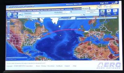
WSI Pilotbrief Online takes the award-winning WSI Pilotbrief weather service suite and provides pilots immediate access to up-to-date enhanced weather updates anywhere, anytime from any Internet-enabled web browser.  One of the few online weather services with FAA Qualified Internet Communications Provider (QICP) certification, Pilotbrief Online allows clients to file flight plans directly to the FAA, as well as view their preferred routes and briefing preferences at any of the numerous WSI Pilotbrief kiosks located in FBO’s throughout the country. 

Through Pilotbrief Online’s secure connection, pilots have direct access to all of WSI’s aviation data including WSI NOWrad radar imagery, IR and Visible Satellite imagery, graphical METARs, TFRs, AIRMETS and SIGMETS.  Radar summary charts indicate potential weather hazards, such as tornadic vortex signatures and mesocyclones, within a planned route for a proactive approach to changing operational conditions.  In addition, the en-route SIGMETS and Flight Plan Guidance provide forecasts for turbulence, convection, and icing, as well as up-to-the-minute Auto Plotted SIGMET and AIRMET charts showing boundaries of in-flight advisories.

With WSI’s Interactive Map, pilots can quickly and easily view global flight data, including route-centric visualization, on a single, easy-to-use interactive workspace. The enhanced map is able to display pole-to-pole, high-resolution digital elevation models with 16 individual weather, hazard, and route overlays.  Such layers include boxes showing areas of turbulence, icing conditions, and even a lightning layer that uses the Global Lightning Network to display real-time lightning detection data for locations throughout the world. 

Pilots can graphically combine various aviation weather and airspace notification layers with just a few mouse clicks.  Developed to be highly extensible, the state-of-the-art interactive map technology allows any future upgrades to be easily added for enhanced options.

FMI: www.wsi.com, www.wsi.com/solutions/aviation/pilotbrief, www.aero-tv.net, www.youtube.com/aerotvnetwork, http://twitter.com/AeroNews

Advertisement

More News

ANN's Daily Aero-Linx (06.29.25)

Aero Linx: Transport Canada We are a federal institution, leading the Transport Canada portfolio and working with our partners. Transport Canada is responsible for transportation p>[...]

ANN's Daily Aero-Term (06.29.25): Gross Navigation Error (GNE)

Gross Navigation Error (GNE) A lateral deviation from a cleared track, normally in excess of 25 Nautical Miles (NM). More stringent standards (for example, 10NM in some parts of th>[...]

Classic Aero-TV: Anticipating Futurespace - Blue Origin Visits Airventure 2017

From AirVenture 2017 (YouTube Edition): Flight-Proven Booster On Display At AirVenture… EAA AirVenture Oshkosh is known primarily as a celebration of experimental and amateu>[...]

NTSB Final Report: Cirrus SR22

Aircraft Parachute System (CAPS) Was Deployed About 293 Ft Above Ground Level, Which Was Too Low To Allow For Full Deployment Of The Parachute System Analysis: The day before the a>[...]

Airborne Affordable Flyers 06.26.25: PA18 Upgrades, ‘Delta Force’, Rhinebeck

Also: 48th Annual Air Race Classic, Hot Air Balloon Fire, FAA v Banning 100LL, Complete Remote Pilot The news Piper PA-18 Super Cub owners have been waiting for has finally arrived>[...]

blog comments powered by Disqus


Advertisement

Advertisement

Podcasts

Advertisement

© 2007 - 2025 Web Development & Design by Pauli Systems, LC