Terra Drone Evaluating GPR Services | Aero-News Network
Aero-News Network
RSS icon RSS feed
podcast icon MP3 podcast
Subscribe Aero-News e-mail Newsletter Subscribe

Airborne Unlimited -- Most Recent Daily Episodes

Episode Date

Airborne-Monday

Airborne-Tuesday

Airborne-Wednesday Airborne-Thursday

Airborne-Friday

Airborne On YouTube

Airborne-Unlimited-11.24.25

AirborneNextGen-
11.18.25

Airborne-Unlimited-11.19.25

Airborne-AffordableFlyers-11.20.25

AirborneUnlimited-11.21.25

LIVE MOSAIC Town Hall (Archived): www.airborne-live.net

Tue, Aug 06, 2019

Terra Drone Evaluating GPR Services

Drone-Deployed Ground Penetrating Radar Would Support Construction And Mining Activities

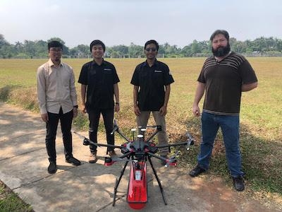
Terra Drone is in the process of evaluating the use of Ground Penetrating Radar (GPR) carried by drones to support the construction and mining industries.

At present, several trials are being carried out in several cases such as making maps of underground pipelines, modeling soil structures in the valley area and detecting the condition of pipes across the river. In this case, Terra Drone took one of his partners from Europe to carry out the trial.
 
Similar to LiDAR, which was previously introduced by Terra Drone, GPR is not a new technology concept, and has been widely used for soil modeling purposes. In principle, GPR shoots electromagnetic waves into the ground, which are then reflected due to differences in the character and density of soil structures, which are then translated by geophysicists to understand in detail the results of the survey. The data collection process is quite simple. However, there are many obstacles that sometimes hinder the process of retrieving data so that the process becomes difficult. One problem is the uneven and dangerous field conditions, difficult access to the mapping location, longer work time, weather conditions and more. With the use of drones, it is expected that these obstacles can be answered, so that the productivity of GPR scanning can increase and the economic value increases rapidly.

The use of drone technology that can bring various sensors for mapping activities is increasingly becoming a solution in various jobs, especially those that are high in risk and danger. Drones with short flight times can reach large mapping areas so that they are efficient in time but still provide accurate results.

This GPR Drone Solution is expected to be a useful innovation in various sectors. Terra Drone will start providing these solutions in Indonesia by the end of 2019.

(Image provided with Terra Drone news release)

FMI: www.terra-drone.co.id

Advertisement

More News

Classic Aero-TV: Pure Aerial Precision - The Snowbirds at AirVenture 2016

From 2016 (YouTube Edition): The Canadian Forces Snowbirds Can Best Be Described As ‘Elegant’… EAA AirVenture 2016 was a great show and, in no small part, it was>[...]

NTSB Final Report: Costruzioni Aeronautiche Tecna P2012 Traveller

Airplane Lunged Forward When It Was Stuck From Behind By A Tug That Was Towing An Unoccupied Airliner Analysis: At the conclusion of the air taxi flight, the flight crew were taxii>[...]

ANN's Daily Aero-Linx (11.23.25)

Aero Linx: International Stinson Club So you want to buy a Stinson. Well the Stinson is a GREAT value aircraft. The goal of the International Stinson Club is to preserve informatio>[...]

ANN's Daily Aero-Term (11.23.25): Request Full Route Clearance

Request Full Route Clearance Used by pilots to request that the entire route of flight be read verbatim in an ATC clearance. Such request should be made to preclude receiving an AT>[...]

Aero-News: Quote of the Day (11.23.25)

"Today's battlefield is adapting rapidly. By teaching our soldiers to understand how drones work and are built, we are giving them the skills to think creatively and apply emerging>[...]

blog comments powered by Disqus


Advertisement

Advertisement

Podcasts

Advertisement

© 2007 - 2025 Web Development & Design by Pauli Systems, LC