New ForeFlight Release Includes High Resolution Basemap | Aero-News Network
Aero-News Network
RSS icon RSS feed
podcast icon MP3 podcast
Subscribe Aero-News e-mail Newsletter Subscribe

Airborne Unlimited -- Most Recent Daily Episodes

Episode Date

Airborne-Monday

Airborne-Tuesday

Airborne-Wednesday Airborne-Thursday

Airborne-Friday

Airborne On YouTube

Airborne-Unlimited-06.17.24

Airborne-NextGen-06.18.24

Airborne-Unlimited-06.12.24 Airborne-FltTraining-06.13.24

Airborne-Unlimited-06.14.24

Mon, Nov 04, 2019

New ForeFlight Release Includes High Resolution Basemap

Shows Detailed Coastlines, Terrain Peaks, Roads, and More

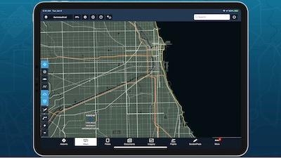
ForeFlight’s new High Resolution Basemap dramatically improves the level of detail visible on the map. View detailed coastlines for rivers, lakes, and oceans to help with visual navigating, and new terrain peak markers with elevation labels for greater terrain awareness.

Other improvements include more detailed roads and railways, urban areas, forests and national parks, and more. ForeFlight automatically downloads the new basemap for your region after you update so you can see the improvements right away.

ForeFlight’s October release also brings map layer multi-select with the “Multiple Selections” setting, AOPA FBO Fees for U.S. airports, a new “Safety Distance Factor” setting for Takeoff & Landing Performance calculations, and more.

Toggle multiple map layers without having to reopen the Layer Selector each time. Enable the new "Multiple Selections" setting at the bottom of the Map Settings menu, or in More > Settings > Layer Selector. You can also now pan and zoom around the map while the layer selector is open, even if the Multiple Selections setting is disabled.
View detailed FBO fees sourced from AOPA’s Airport Directory to help you make more informed flight planning decisions. Access fee information in the new Fees tab of the FBO detail view. For each FBO ForeFlight lists the type of fee, the fee amount, any notes, and a detailed breakdown for fees that vary by aircraft type.
Increase your safety margins for Takeoff & Landing Performance calculations based on runway conditions and other factors. ForeFlight multiplies the initial distance amount by the Safety Distance Factor to produce the final result, and automatically applies your last-used factor for future flights with the same aircraft.
ForeFlight can now automatically fill certain Logbook fields based on a flight’s Total Time, simplifying the process of filling in new entries. Select the fields you want to auto-fill in More > Logbook > Settings > Auto-Fill Settings.

(Image from ForeFlight YouTube video. Source: ForeFlight news release)

FMI: www.foreflight.com

Advertisement

More News

ANN FAQ: Submit a News Story!

Have A Story That NEEDS To Be Featured On Aero-News? Here’s How To Submit A Story To Our Team Some of the greatest new stories ANN has ever covered have been submitted by our>[...]

Aero-News: Quote of the Day (06.12.24)

“The legislation now includes a task force with industry representation ensuring that we have a seat at the table and our voice will be heard as conversations about the futur>[...]

ANN's Daily Aero-Linx (06.12.24)

Aero Linx: Waco Museum The WACO Historical Society, in addition to preserving aviation's past, is also dedicated and actively works to nurture aviation's future through its Learnin>[...]

ANN's Daily Aero-Term (06.12.24): Adcock Range

Adcock Range National low-frequency radio navigation system (c.1930-c.1950) replaced by an omnirange (VOR) system. It consisted of four segmented quadrants broadcasting Morse Code >[...]

Airborne Affordable Flyers 06.06.24: 200th ALTO, Rotax SB, Risen 916iSV

Also: uAvionix AV-Link, Does Simming Make Better Pilots?, World Games, AMA National Fun Fly Czech sportplane manufacturer Direct Fly has finished delivering its 200th ALTO NG, the >[...]

blog comments powered by Disqus


Advertisement

Advertisement

Podcasts

Advertisement

© 2007 - 2024 Web Development & Design by Pauli Systems, LC