Thu, Apr 06, 2017
Jeppesen Charts Now Updated Wirelessly Through Garmin Flight Stream 510
Garmin International and Jeppesen recently announced new wireless data transfer capabilities for Jeppesen terminal charts that are accessed through select Garmin avionics and the iOS-based Garmin Pilot app. This development enhances the integrated data capabilities from the two companies that advance cockpit technology and improve the flying experience for general aviation pilots.
“The ability to provide wireless data updates streamlines the flight preparation process and allows pilots to take the skies more quickly,” said Scott Reagan, director, Jeppesen OEM Client Management. “This wireless data transfer capability illustrates how Garmin and Jeppesen work together to simplify the delivery of essential flight data to private pilots flying with Garmin avionics and Garmin Pilot.”
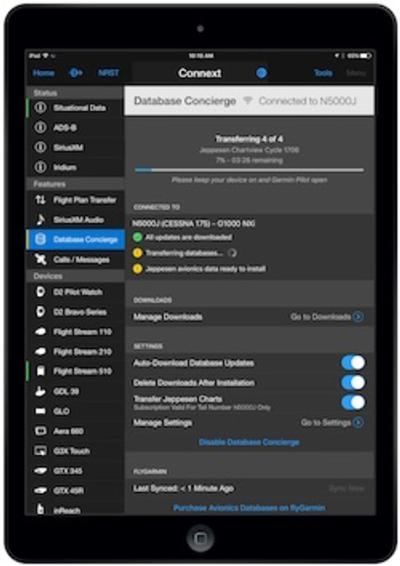
Pilots using the GTN 650/750 touchscreen navigator or the G1000 NXi integrated flight deck with Flight Stream 510 will now be able to wirelessly transfer Jeppesen terminal charts through the iOS-based Garmin Pilot app to their avionics systems. The Flight Stream 510 MultiMediaCard (MMC) from Garmin includes Database Concierge, the tool that transfers Jeppesen aviation database updates from the app to supported Garmin avionics.
“As we continue to pack more features and capabilities into Garmin Pilot, we’re excited to provide our customers around the world with a premier application that they can utilize throughout every phase of flight,” said Carl Wolf, Garmin vice president of aviation sales and marketing. “As our global customer base continues to grow, we are excited to further expand game-changing app capabilities, including wireless connectivity with Jeppesen and other enhancements that provide access to information for pilots to make the best informed decisions on the ground and in-flight.”
Jeppesen terminal charts can be viewed within Garmin Pilot from the charts page and in split screen mode alongside the moving map. Geo-referenced Jeppesen charts can also be overlaid on the moving map for seamless navigation. An electronic Jeppesen chart subscription for Garmin Pilot is required to access Jeppesen terminal charts through the app.
(Image provided with Jeppesen news release)
More News
“Honored to accept this mission. Time to take over space. Let’s launch.” Source: SecTrans Sean Duffy commenting after President Donald Trump appointed U.S. Secret>[...]
Permanent Echo Radar signals reflected from fixed objects on the earth's surface; e.g., buildings, towers, terrain. Permanent echoes are distinguished from “ground clutter&rd>[...]
Aero Linx: European Hang Gliding and Paragliding Union (EHPU) The general aim of the EHPU is to promote and protect hang gliding and paragliding in Europe. In order to achieve this>[...]
Glider Encountered A Loss Of Lift And There Was Not Sufficient Altitude To Reach The Airport Analysis: The flight instructor reported that while turning final, the glider encounter>[...]
Airplane Climbed To 100 Ft Above Ground Level, At Which Time The Airplane Experienced A Total Loss Of Engine Power On May 24, 2025, at 1300 eastern daylight time, an Aeronca 7AC, N>[...]
 Aero-News: Quote of the Day (07.11.25)