Wed, Aug 07, 2013
Plates On Maps, Flight Alerts, And Aerial Satellite Imagery Included In Version 5.3
The sixth significant release of ForeFlight Mobile this year is now available for download from App Store. ForeFlight Mobile 5.3 will allow users to view plate and taxi diagram map overlays on any of ForeFlight’s own 13,000+ geo-referenced diagrams and 700+ geo-referenced airport diagrams on the moving map.
The update also includes: Flight Alerts. When filing IFR through ForeFlight, users will be updated when their expected route clearance is available. It can then be viewed directly on the moving map or see your flight track on FlightAware after landing; A new Aerial map layer, providing a bird’s eye view of the user's route and a preview of the terminal area; An enhanced instruments panel that shows eight instruments (on iPad in landscape) and has an improved design; Updated direct-connect drivers for Bad Elf and DUAL GPS devices, improving GPS performance and stability; and Updated Stratus 2 firmware, which includes an enhancement that improves WiFi and high-altitude GPS performance.
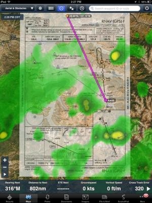
The "Plates on a Map and Taxi Diagrams on a Map" Pro Feature is one of the many products emerging from ForeFlight's semi-annual Hack Week held in Austin earlier this summer. With this feature, users can display any geo-referenced approach plate or taxi diagram right on the map. Benefits of the new feature include:
- Track-up or north-up approach plates! When plates are on the map, you can fly them in track-up forward, track-up centered or north-up modes.
- The ability to overlay both internet and airborne ADS-B or XM weather on approaches! Overlay flight rules, NEXRAD radar, and see weather conditions at nearby alternates.
- Approach plate hazard awareness for terrain and obstacles! If Hazard Advisor is active, terrain and obstacles are colored, raising situational awareness.
- Traffic information displayed on approach plates! If you have a Stratus or Stratus 2 portable ADS-B receiver and an ADS-B out equipped aircraft, see traffic targets displayed on the approach.
- Route overlay on top of approach plates! With the approach plate on the map, it is easy to add approach waypoints to your route that line up with the selected approach path.
This is part of the ForeFlight Pro subscription, available for $149.99/yr. Subscribers to the standard package can visit the website to upgrade to Pro. Just make sure to enter the same email used to purchase the original ForeFlight subscription and you’ll receive pro-rated credit for your upgrade.
In addition to these new benefits, a Plate transparency slider is available that, when adjusted, lets you see through to the underlying sectional chart, terrain, or aerial map.
(Pictured: Weather on approach overlay screenshot provided by ForeFlight)
More News
Cooperative Surveillance Any surveillance system, such as secondary surveillance radar (SSR), wide-area multilateration (WAM), or ADS-B, that is dependent upon the presence of cert>[...]
Aero Linx: OX5 Aviation Pioneers Incorporated in 1955 as a Pa 501 (c)(3) Not for Profit Corporation, the OX5 Aviation Pioneers is dedicated to bringing before the public the accomp>[...]
The Pilot Appeared To Regain Control After Six Rotations And Attempted To “Fly Out” Inverted But Had Insufficient Altitude On November 8, 2025, at 1038 eastern standard>[...]
From 2018 (YouTube Edition): Aero-News Talks With The Airplane's Builder One of the many unique airplanes at AirVenture 2018 was a 1/3-scale B-17 bomber built by Jack Bally, who ta>[...]
Aero Linx: Society of U.S. Army Flight Surgeons (SoUSAFS) The Society of US Army Flight Surgeons (SoUSAFS) serves to advance the science and art of Aerospace Medicine and its allie>[...]
 ANN's Daily Aero-Term (12.04.25): Cooperative Surveillance

