Airbus Extends Its Reach Into Precision Agriculture Solutions With AgNeo | Aero-News Network
Aero-News Network
RSS icon RSS feed
podcast icon MP3 podcast
Subscribe Aero-News e-mail Newsletter Subscribe

Airborne Unlimited -- Most Recent Daily Episodes

Episode Date

Airborne-Monday

Airborne-Tuesday

Airborne-Wednesday Airborne-Thursday

Airborne-Friday

Airborne On YouTube

Airborne-Unlimited-06.23.25

Airborne-NextGen-06.24.25

AirborneUnlimited-06.25.25

Airborne-AffordableFlyers-06.26.25

AirborneUnlimited-06.27.25

Mon, Mar 16, 2020

Airbus Extends Its Reach Into Precision Agriculture Solutions With AgNeo

A New Precision Farming Solution For Commodity And Permanent Crops

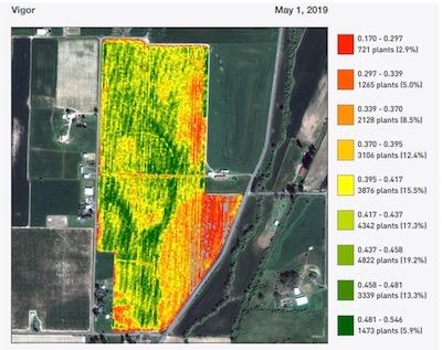
Airbus has launched AgNeo, its new integrated precision farming solution for commodity and permanent crops. Delivering in-season actionable information based on satellite imagery and premium agronomic analytics, AgNeo will help customers save time, optimise inputs and increase yields.

AgNeo leverages Airbus’ 30-year experience in the agriculture market and the long-standing and fruitful collaboration with its customers to propose a wide range of crop analytics. Based on imagery-derived health maps from SPOT, Pléiades, Sentinel-2 and Landsat 8 data, they support a wide range of capabilities: from alerting features that direct agronomists to scout areas in their fields that require immediate attention, to the creation of management zones and variable rate application maps. Thanks to an Airbus-proprietary processing chain that normalizes data across all sensors, AgNeo customers can also derive absolute agronomic indicators to use as input to their own models for building nitrogen recommendation or establishing water budgets.

AgNeo also provides enhanced analytics for high value permanent crops such as almonds, apples and grapes. Using 20-inch resolution data from Pléiades, AgNeo creates a mask of all the tree crowns to remove noise from background vegetation and soil, improving the results and bringing analytics to the tree level. These analytics include a stand count inventory eliminating time-consuming and error-prone manual tree counts. The product will be able to utilize 12-inch data from Airbus’ new Pléiades Neo satellites due to be launched later this year.

The AgNeo solution is available with a full user interface and will also be accessible via APIs.

(Image provided with Airbus news release)

FMI: www.airbus.com

Advertisement

More News

ANN's Daily Aero-Linx (06.29.25)

Aero Linx: Transport Canada We are a federal institution, leading the Transport Canada portfolio and working with our partners. Transport Canada is responsible for transportation p>[...]

ANN's Daily Aero-Term (06.29.25): Gross Navigation Error (GNE)

Gross Navigation Error (GNE) A lateral deviation from a cleared track, normally in excess of 25 Nautical Miles (NM). More stringent standards (for example, 10NM in some parts of th>[...]

Classic Aero-TV: Anticipating Futurespace - Blue Origin Visits Airventure 2017

From AirVenture 2017 (YouTube Edition): Flight-Proven Booster On Display At AirVenture… EAA AirVenture Oshkosh is known primarily as a celebration of experimental and amateu>[...]

NTSB Final Report: Cirrus SR22

Aircraft Parachute System (CAPS) Was Deployed About 293 Ft Above Ground Level, Which Was Too Low To Allow For Full Deployment Of The Parachute System Analysis: The day before the a>[...]

Airborne Affordable Flyers 06.26.25: PA18 Upgrades, ‘Delta Force’, Rhinebeck

Also: 48th Annual Air Race Classic, Hot Air Balloon Fire, FAA v Banning 100LL, Complete Remote Pilot The news Piper PA-18 Super Cub owners have been waiting for has finally arrived>[...]

blog comments powered by Disqus


Advertisement

Advertisement

Podcasts

Advertisement

© 2007 - 2025 Web Development & Design by Pauli Systems, LC