Fri, Mar 06, 2020
Lufthansa Systems, Intermap Technologies Obtain First EASA Certification For Global Terrain Data
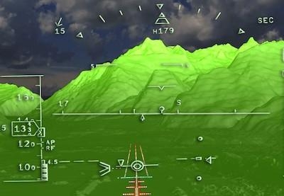
Lufthansa Systems and Intermap Technologies announced that Lido Surface Data NEXTView has received the Service Provider Type 1 Certificate from EASA. Lido Surface Data NEXTView is the world’s first high-resolution, global terrain dataset specifically designed for the aviation industry. It provides the highest quality of data with continual updates and incorporates Lido’s aerodrome database, significantly increasing the accuracy around aerodromes. The solution is currently the only certified digital surface model on the market that fulfills all relevant industry standards.
Lido Surface Data NEXTView was developed in collaboration with Intermap Technologies, an industry leader in geospatial intelligence solutions with long-standing expertise in the field of digital elevation models. “We are extremely proud to be the first to receive an EASA certificate for our newly developed terrain product,” said Michael Sauter, Senior Product Owner for Aeronautical Data at Lufthansa Systems. “Lido Surface Data NEXTView is further enriching our aeronautical data portfolio and provides a fundamental database for the increasingly digitally driven future of mobility.”
With the newly certified terrain product, Lufthansa Systems is enabling the aviation industry to further enhance solutions such as:
- synthetic vision systems (SVS) as well as enhanced and combined vision systems (EVS, CVS), which provide pilots with greater situational awareness; and
- terrain awareness and ground proximity warning systems (TAWS, EGPWS), which allow aircraft and helicopters to maintain a safe distance from the ground.
Furthermore, the solution serves the wider aviation market by enabling the development of innovative applications for:
- flight planning, procedure design and performance calculations; and
- drone operations and drone planning, increasing the efficiency of flight operations.
“This announcement is a milestone for Intermap Technologies’ data business,” said Patrick Blott, Chairman and CEO of Intermap Technologies. “With the certification of Lido Surface Data NEXTView, we are now able to work with our partners at Lufthansa Systems to consistently and globally deliver high-resolution information that aviators and airlines need to improve the customer experience, navigation and safety. Commercial airlines, UAV companies and governments all over the world can rely on their subscriptions to the Lido Surface Data NEXTView data to power critical automated systems and make flying even safer and more efficient.”
(Image provided with Lufthansa Systems news release)
More News
Pilot Also Reported That Due To A Fuel Leak, The Auxiliary Fuel Tanks Were Not Used On June 4, 2025, at 13:41 eastern daylight time, a Piper PA-23, N2109P, was substantially damage>[...]
Have A Story That NEEDS To Be Featured On Aero-News? Here’s How To Submit A Story To Our Team Some of the greatest new stories ANN has ever covered have been submitted by our>[...]
From 2023 (YouTube Edition): Reflections on War’s Collective Lessons and Cyclical Nature The exigencies of war ought be colorblind. Inane social-constructs the likes of racis>[...]
Aero Linx: Colorado Pilots Association (CPA) Colorado Pilots Association was incorporated as a Colorado Nonprofit Corporation in 1972. It is a statewide organization with over 700 >[...]
High Speed Taxiway A long radius taxiway designed and provided with lighting or marking to define the path of aircraft, traveling at high speed (up to 60 knots), from the runway ce>[...]
 NTSB Prelim: Piper PA-23

