NASA Mars Orbiter Spies Rover Near Martian Butte | Aero-News Network
Aero-News Network
RSS icon RSS feed
podcast icon MP3 podcast
Subscribe Aero-News e-mail Newsletter Subscribe

Airborne Unlimited -- Most Recent Daily Episodes

Episode Date

Airborne-Monday

Airborne-Tuesday

Airborne-Wednesday Airborne-Thursday

Airborne-Friday

Airborne On YouTube

Airborne-Unlimited-06.10.24

Airborne-NextGen-06.11.24

Airborne-Unlimited-06.12.24 Airborne-FltTraining-06.13.24

Airborne-Unlimited-06.14.24

Mon, Apr 21, 2014

NASA Mars Orbiter Spies Rover Near Martian Butte

Curiosity Spotted At Work Near 'Mount Remarkable'

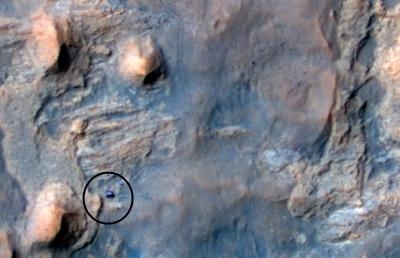
Scientists using NASA's Curiosity Mars rover are eyeing a rock layer surrounding the base of a small butte, called "Mount Remarkable," as a target for investigating with tools on the rover's robotic arm. And this image of the rover at work was captured April 11 by the High Resolution Imaging Science Experiment (HiRISE) camera on NASA's Mars Reconnaissance Orbiter.

The butte stands about 16 feet high. Curiosity's science team refers to the rock layer surrounding the base of Mount Remarkable as the "middle unit" because its location is intermediate between rocks that form buttes in the area and lower-lying rocks that show a pattern of striations.

Depending on what the mission scientists learn from a close-up look at the rock and identification of chemical elements in it, a site on this middle unit may become the third rock that Curiosity samples with its drill. The rover carries laboratory instruments to analyze rock powder collected by the drill. The mission's first two drilled samples, in an area called Yellowknife Bay near Curiosity's landing site, yielded evidence last year for an ancient lakebed environment with available energy and ingredients favorable for microbial life.

The rover's current location, where multiple types of rocks are exposed close together, is called "the Kimberley." Here and, later, at outcrops on the slope of Mount Sharp inside Gale Crater, researchers plan to use Curiosity's science instruments to learn more about habitable past conditions and environmental changes.

(Image provided by NASA)

FMI: www.nasa.gov/msl

Advertisement

More News

ANN FAQ: Submit a News Story!

Have A Story That NEEDS To Be Featured On Aero-News? Here’s How To Submit A Story To Our Team Some of the greatest new stories ANN has ever covered have been submitted by our>[...]

Aero-News: Quote of the Day (06.12.24)

“The legislation now includes a task force with industry representation ensuring that we have a seat at the table and our voice will be heard as conversations about the futur>[...]

ANN's Daily Aero-Linx (06.12.24)

Aero Linx: Waco Museum The WACO Historical Society, in addition to preserving aviation's past, is also dedicated and actively works to nurture aviation's future through its Learnin>[...]

ANN's Daily Aero-Term (06.12.24): Adcock Range

Adcock Range National low-frequency radio navigation system (c.1930-c.1950) replaced by an omnirange (VOR) system. It consisted of four segmented quadrants broadcasting Morse Code >[...]

Airborne Affordable Flyers 06.06.24: 200th ALTO, Rotax SB, Risen 916iSV

Also: uAvionix AV-Link, Does Simming Make Better Pilots?, World Games, AMA National Fun Fly Czech sportplane manufacturer Direct Fly has finished delivering its 200th ALTO NG, the >[...]

blog comments powered by Disqus


Advertisement

Advertisement

Podcasts

Advertisement

© 2007 - 2024 Web Development & Design by Pauli Systems, LC