Fri, May 16, 2003
Airdrop Behavior of Cargo Pallets Testing
Thales Navigation, a leading provider of GPS solutions for
positioning, navigation and communications applications, is playing
an important role in the U.S. military's efforts to assess and
optimize parachute-rigging designs for the airdropping of large
cargo pallets.
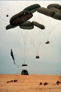 In a
series of tests conducted by the U.S. Army Operational Test
Command, Airborne and Special Operations Test Directorate in Fort
Bragg (NC), Thales Navigation's G12 GPS receiver was used in
concert with an inertial measurement unit (IMU) to record and
analyze parachute payload behavior - including continuous
positioning, velocity and attitude -- during and after exit from an
aircraft. The instrumentation package, called the Airborne Position
Location Instrumentation (APLS) system, was developed for the Army
Operational Test Command by SRI International, an independent
research organization in Menlo Park (CA).
In a
series of tests conducted by the U.S. Army Operational Test
Command, Airborne and Special Operations Test Directorate in Fort
Bragg (NC), Thales Navigation's G12 GPS receiver was used in
concert with an inertial measurement unit (IMU) to record and
analyze parachute payload behavior - including continuous
positioning, velocity and attitude -- during and after exit from an
aircraft. The instrumentation package, called the Airborne Position
Location Instrumentation (APLS) system, was developed for the Army
Operational Test Command by SRI International, an independent
research organization in Menlo Park (CA).
Operational requirements for the GPS receiver included a
relatively high differential update rate of at least 10 Hz. The
Thales unit offered 20 Hz. In addition, the receiver needed to
supply analyzable raw data, which the G12 was also able to
provide.
Reacquiring satellite signals
The G12 performed its role of providing time reference
information and calibration of the IMU strongly in other ways. As
the pallet was released from the aircraft in testing, the receiver
would temporarily lose contact with the GPS satellites for a few
seconds as an external antenna on the receiver reacquired the
satellite signal. During that brief period, an inertial measurement
unit (IMU) collected data as a backup. The G-12 performed well in
signal reacquisition tests.
The testing also called for rugged, relatively shockproof
equipment. The receiver and the IMU were both housed in a 10-pound
aluminum-encased package along with a small computer, CPU card and
an external battery. Pallets carrying some 30,000 pounds of cargo
were dropped from altitudes of 1,500 feet from aircraft flying at
120 miles per hour. Pallet loads often undergo forces of 2 to 4 g's
upon extraction from the aircraft and up to 100 g's on landing -
stresses that call for unusually rugged measurement equipment. The
combination of good update rates and reliable performance provided
meaningful data and positioning readings.
More News
From 2023 (YouTube Edition): "Ain’t Your Daddy’s Super Cub”—Don Wade Co-owned by Don and Ron Wade—the former of Don’s Dream Machines, a storied >[...]
Pilot-Rated Passenger Reported That The Pilot Did Not Adequately “Round Out” The Landing Flare And The Airplane Bounced And Yawed To The Right Analysis: The pilot state>[...]
Dead Reckoning Dead reckoning, as applied to flying, is the navigation of an airplane solely by means of computations based on airspeed, course, heading, wind direction, and speed,>[...]
Aero Linx: Lake Amphibian Club This website is created and sponsored by the Lake Amphibian Club, to help spread the word about these wonderful, versatile amphibians that can land j>[...]
“I am deeply honored to be sworn in as NASA administrator. NASA’s mission is as imperative and urgent as ever — to push the boundaries of human exploration, ignit>[...]
 Classic Aero-TV: In Praise of Alabamas Patriot Aircraft USA

