Sat, Feb 23, 2008
 NOTAM Number: FDC 8/5721
Issue Date: February 22, 2008 at 1731 UTC
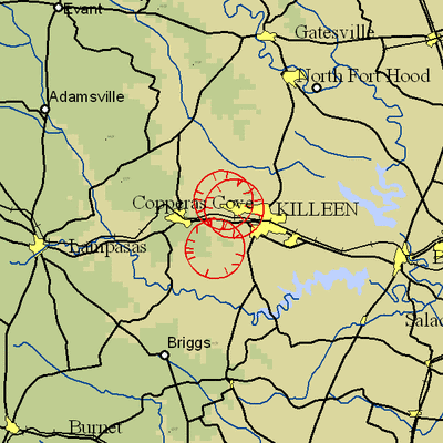
Location: Fort Hood, Texas
Beginning Date and Time: February 26, 2008 at 1355 UTC
Ending Date and Time: February 26, 2008 at 1710 UTC
Reason for NOTAM: Temporary flight restrictions for VIP (Very
Important Person) Movement
Type: VIP
Replaced NOTAM(s): N/A
Affected Area(s)
Area A
Airspace Definition:
Center: On the GRAY VOR/DME (GRK) 333 degree radial at 2.2
nautical miles. (Latitude: 31º04'01"N, Longitude:
97º49'42"W)
Radius: 3 nautical miles
Altitude: From the surface up to but not including 3000 feet
AGL
Effective Date(s):
From February 26, 2008 at 1355 UTC (February 26, 2008 at 0755
CST)
To February 26, 2008 at 1445 UTC (February 26, 2008 at 0845
CST)
Area B
Airspace Definition:
Center: On the GRAY VOR/DME (GRK) 003 degree radial at
6.3 nautical miles. (Latitude: 31º08'09"N, Longitude:
97º47'33"W)
Radius: 3 nautical miles
Altitude: From the surface up to but not including 3000 feet
AGL
Effective Date(s):
From February 26, 2008 at 1415 UTC (February 26, 2008 at 0815
CST)
To February 26, 2008 at 1610 UTC (February 26, 2008 at 1010
CST)
Area C
Airspace Definition:
Center: On the GRAY VOR/DME (GRK) 353 degree radial at 7
nautical miles. (Latitude: 31º08'58"N, Longitude:
97º48'50"W)
Radius: 3 nautical miles
Altitude: From the surface up to but not including 3000 feet
AGL
Effective Date(s):
From February 26, 2008 at 1540 UTC (February 26, 2008 at 0940
CST)
To February 26, 2008 at 1650 UTC (February 26, 2008 at 1050
CST)
Area D
Airspace Definition:
Center: On the GRAY VOR/DME (GRK) 333 degree radial at
2.2 nautical miles. (Latitude: 31º04'01"N, Longitude:
97º49'42"W)
Radius: 3 nautical miles
Altitude: From the surface up to but not including 3000 feet
AGL
Effective Date(s):
From February 26, 2008 at 1620 UTC (February 26, 2008 at 1020
CST)
To February 26, 2008 at 1710 UTC (February 26, 2008 at 1110
CST)
Operating Restrictions and Requirements
No pilots may operate an aircraft in the areas covered by this
NOTAM (except as described).
Unless otherwise authorized by ATC.
Other Information:
ARTCC: ZHU - Houston Center
Authority: Title 14 CFR section 91.141
FMI: www.tfr.faa.gov,
Depicted TFR data may not be a complete listing. Pilots should not
use the information on this website for flight planning purposes.
For the latest information, call your local Flight Service Station
at 1-800-WX-BRIEF.
More News
Aero Linx: Transport Canada We are a federal institution, leading the Transport Canada portfolio and working with our partners. Transport Canada is responsible for transportation p>[...]
Gross Navigation Error (GNE) A lateral deviation from a cleared track, normally in excess of 25 Nautical Miles (NM). More stringent standards (for example, 10NM in some parts of th>[...]
From AirVenture 2017 (YouTube Edition): Flight-Proven Booster On Display At AirVenture… EAA AirVenture Oshkosh is known primarily as a celebration of experimental and amateu>[...]
Aircraft Parachute System (CAPS) Was Deployed About 293 Ft Above Ground Level, Which Was Too Low To Allow For Full Deployment Of The Parachute System Analysis: The day before the a>[...]
Also: 48th Annual Air Race Classic, Hot Air Balloon Fire, FAA v Banning 100LL, Complete Remote Pilot The news Piper PA-18 Super Cub owners have been waiting for has finally arrived>[...]
 ANN's Daily Aero-Linx (06.29.25)

