Weather Was IMC When Wreckage Was Found, ELT Antenna Cable Had
Separated
 The preliminary report on the
Alaska accident which fatally injured former Alaska Senator Ted
Stevens and 4 others has been released by the NTSB. The board
confirms that weather was pretty awful on the mountain when
rescuers reached the crash site, about six hours after the plane
went down, but that reports from Dillingham at the time of the
accident were marginal VFR. The report also says the plane's ELT
had come loose from its bracket, and the antenna cable was
separated.
The preliminary report on the
Alaska accident which fatally injured former Alaska Senator Ted
Stevens and 4 others has been released by the NTSB. The board
confirms that weather was pretty awful on the mountain when
rescuers reached the crash site, about six hours after the plane
went down, but that reports from Dillingham at the time of the
accident were marginal VFR. The report also says the plane's ELT
had come loose from its bracket, and the antenna cable was
separated.
NTSB Identification: ANC10MA068
Nonscheduled 14 CFR Part 91: General Aviation
Accident occurred Monday, August 09, 2010 in Aleknagik, AK
Aircraft: DEHAVILLAND DHC-3, registration: N455A
Injuries: 5 Fatal, 4 Serious.
This is preliminary information, subject to change, and may
contain errors. Any errors in this report will be corrected when
the final report has been completed.
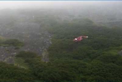
On August 9, 2010, about 1445 Alaska daylight time (ADT), a
single engine, turbine-powered, amphibious float-equipped de
Havilland DHC-3T (Otter) airplane, N455A, sustained substantial
damage when it impacted mountainous tree-covered terrain, about 10
miles northeast of Aleknagik, Alaska. The airplane was registered
to and operated by General Communication Corporation (GCI),
Anchorage, Alaska, and the flight was being conducted under the
provisions of 14 Code of Federal Regulations Part 91 when the
accident occurred. Of the nine people aboard, the airline transport
pilot and four passengers died at the scene, and four passengers
sustained serious injuries. At the time of the accident, marginal
visual meteorological conditions were reported at the Dillingham
Airport, about 18 miles south of the accident site. The weather
conditions at the accident site at that time are not known;
however, searchers encountered instrument meteorological conditions
(IMC) when they arrived at the accident site almost 6 hours later.
The flight originated from a GCI-owned remote fishing lodge on the
southwest shoreline of Lake Nerka, about 1430 ADT. The flight was
en route to a remote sport fishing camp on the banks of the
Nushagak River, about 52 miles southeast of the GCI lodge. No
flight plan was filed.
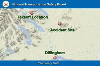
NTSB Map
According to a GCI representative, before the airplane departed
GCI’s lodge, the accident pilot telephoned personnel at the
sport fishing camp to tell them that the airplane would be en route
to the camp, with an anticipated arrival time between 1430 and 1500
ADT. The GCI representative stated that after the airplane departed
the lodge about 1430 ADT, no further communications were received
from the pilot.
About 1815 ADT, GCI's lodge manager contacted personnel at the
sports fishing camp to inquire about the airplane's proposed return
time, and to ask if the guests had any dinner requests upon their
return. The fishing camp personnel told the GCI lodge manager that
the airplane had not arrived, and that they assumed that the pilot
had chosen a different fishing destination. The GCI lodge manager
then initiated a phone and radio search to see if the airplane had
diverted to Dillingham, Alaska or if it was en route back to the
GCI lodge. Unable to locate the airplane, GCI lodge personnel
initiated an aerial search along the pilot's anticipated route.
Additional search airplanes and helicopters in the area voluntarily
joined the search for the missing airplane. The airplane was
officially reported overdue to the Federal Aviation Administration
at 1859 ADT.
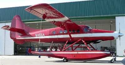
DHC-3T NTSB Photo
About 2005 ADT, volunteer airborne search personnel located the
wreckage along the anticipated flight route, about 900 feet above
mean sea level in the Muklung Hills, in steep, heavily wooded
terrain, about 19 miles southeast of the GCI lodge. A team of
volunteer search members reached the accident site by helicopter
and confirmed that the pilot and four passengers died at the scene,
and four passengers sustained serious injuries.
Because poor weather and dark night conditions prohibited
additional rescue personnel from reaching the accident site until
the next morning, the four seriously injured passengers and their
rescuers remained at the accident site overnight. The following
morning, a U.S. Coast Guard HH-60J helicopter from Air Station
Kodiak, and a HH-60G helicopter from the Air National Guard's 210th
Air Rescue Squadron, Anchorage, evacuated all personnel from the
accident site.
Accident Site NTSB Photo
The closest weather reporting facility was the Dillingham
Airport, about 18 miles south of the accident site. At 1455 ADT,
about 10 minutes after the presumed time of the accident, the
Dillingham weather observation reported, in part: wind, 180°
(true) at 12 knots, gusting to 23 knots; visibility, 3 statute
miles with light rain and mist; clouds and sky condition, 600 feet
scattered, 1,000 feet overcast; temperature, 52° Fahrenheit
(F); dew point, 48° F; altimeter, 29.58 inches of Mercury.
No emergency locator transmitter (ELT) signal was detected
during the aerial search. (The accident airplane was equipped with
an Artex ME406 ELT. Examination of the wreckage revealed that the
ELT had separated from its mounting bracket during impact, and the
antenna cable was found separated from the ELT.)
 ANN's Daily Aero-Linx (04.30.25)