Lockheed Martin Nabs $297M NASA Contract | Aero-News Network
Aero-News Network
RSS icon RSS feed
podcast icon MP3 podcast
Subscribe Aero-News e-mail Newsletter Subscribe

Airborne Unlimited -- Most Recent Daily Episodes

Episode Date

Airborne-Monday

Airborne-Tuesday

Airborne-Wednesday Airborne-Thursday

Airborne-Friday

Airborne On YouTube

Airborne-Unlimited-01.13.25

Airborne-NextGen-01.14.25

Airborne-Unlimited-01.15.25

Airborne-FltTraining-01.16.25

Airborne-Unlimited-01.17.25

Sat, Sep 21, 2024

Lockheed Martin Nabs $297M NASA Contract

To Build Lightning-Mapping Instrument For NOAA’s GeoXO Satellite

NASA announced that it has selected Lockheed Martin Corporation to develop a lightning mapping instrument for the National Oceanic and Atmospheric Administration (NOAA). The instrument will be incorporated into NOAA’d Geostationary Extended Observations satellite program, anticipated to begin operations in the early 2030s as the current Geostationary Operational Environmental Satellites-R series (GOES-R) approach the end of their operational lifetime.

The contract is valued at about $297.1 million and includes two flight instruments plus options for two additional units. The performance period of the contract includes support for 10 years of on-orbit operations and five years of on-orbit storage prior to the start of operational observations and data relay.

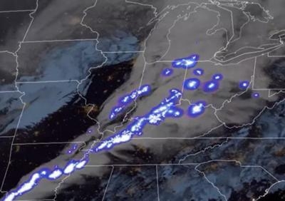
The Lightning Mapper instrument will detect, locate, and measure the intensity, duration, and extent of lightning flashes. Data from the instrument will be used to analyze severe storms, increase warning time for hazardous weather, and provide earlier indications of impending lightning strikes to the ground. The data will also be incorporated into predicting hurricane intensity, detecting wildfires, estimate precipitation, and mitigate hazards to aviation.

The suite of instruments aboard the GeoXO satellite will monitor the Western Hemisphere as an element of NOAA’s observation system supporting short-term forecasts and warnings for extreme weather and long-term planning related to climate. The data are used in climate-forecasting models used to predict weather patterns and detect any emerging patterns potentially related to climate change.

FMI:  www.nesdis.noaa.gov/

Advertisement

More News

ANN's Daily Aero-Linx (01.15.25)

Aero Linx: Airports Council International (ACI) Airports Council International (ACI) represents the collective interests of airports around the world to promote excellence in the a>[...]

ANN's Daily Aero-Term (01.15.25): Go Around

Go Around Instructions for a pilot to abandon his/her approach to landing. Additional instructions may follow. Unless otherwise advised by ATC, a VFR aircraft or an aircraft conduc>[...]

Aero-News: Quote of the Day (01.15.25)

“I’m kind of excited to see what the new owner does with it.” Source: Airport Director Tony Nevarez, discussing the non-airworthy Boeing 727 airliner built in 196>[...]

Aero-News: Quote of the Day (01.16.25)

“The market demand for TBM and Kodiak continues to be resilient, benefitting from the versatility and operational efficiency of these aircraft – which is backed by Dahe>[...]

ANN's Daily Aero-Term (01.16.25): Waypoint

Waypoint A predetermined geographical position used for route/instrument approach definition, progress reports, published VFR routes, visual reporting points or points for transiti>[...]

blog comments powered by Disqus


Advertisement

Advertisement

Podcasts

Advertisement

© 2007 - 2025 Web Development & Design by Pauli Systems, LC